Hastings-on-Hudson night lights from space
Night Light of Hastings-on-Hudson (New York) from space (United States) Src. Average luminocity for 10x10km area is 66.7126% and for 50x50km: 66.0375%.
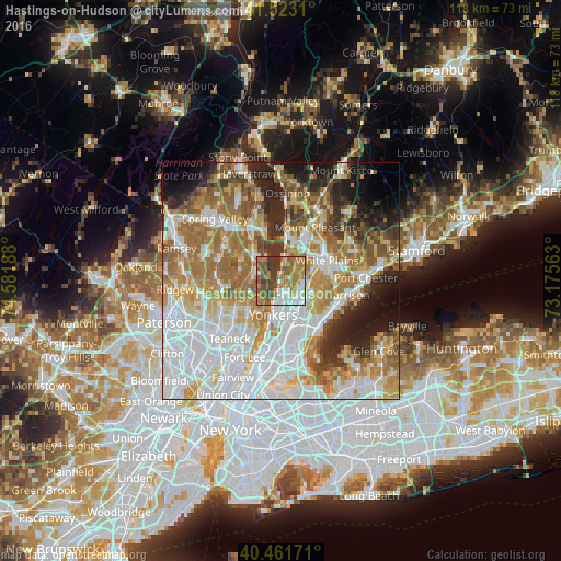
Analysis of Hastings-on-Hudson night lights 2016
Square area 10x10 km:
 11.9%
11.9%90-99
9.86%80-89
5.61%70-79
11.56%60-69
22.79%50-59
15.65%40-49
8.16%30-39
14.46%20-29
0%10-19
0%0-9
0%Square area 50x50 km:
20.01%90-99
14.44%80-89
7.3%70-79
9.48%60-69
12.67%50-59
7.24%40-49
4.82%30-39
4.75%20-29
6.84%10-19
7.17%0-9
5.28%Clear (daylight) street map image can be seen on geolist.org.
Map coordinates:
41° 31' 23.2" North, 74° 34' 54.8" West
40° 59' 40.3" North, 73° 52' 43.5" West
40° 27' 42.2" North, 73° 10' 32.3" West
Some cities around Hastings-on-Hudson sort by population:
• Greenburgh
5.2 km =3.2 mi,  35°
35°
• Eastchester
7.1 km =4.4 mi,  124°
124°
• Dobbs Ferry
2.3 km =1.4 mi,  12°
12°
• Greenville
4.9 km =3 mi,  91°
91°
• Tuckahoe
6.5 km =4 mi,  138°
138°
• Tappan
6.5 km =4 mi,  297°
297°
• Irvington
5 km =3.1 mi, 10°
• Norwood
7 km =4.3 mi,  273°
273°
5120197 (p: 8,014)
Sources (retrieved 2019-11-25):
» Earth at Night: Flat Maps 2012, 2016