Tappan night lights from space
Night Light of Tappan (New York) from space (United States) Src. Average luminocity for 10x10km area is 59.4677% and for 50x50km: 64.0823%.
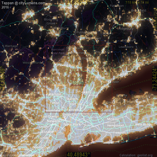
Analysis of Tappan night lights 2016
Square area 10x10 km:
 4.42%
4.42%90-99
4.08%80-89
5.44%70-79
12.24%60-69
20.75%50-59
24.66%40-49
9.86%30-39
18.2%20-29
0.34%10-19
0%0-9
0%Square area 50x50 km:
18.35%90-99
14.04%80-89
7.44%70-79
9.11%60-69
12.72%50-59
7.46%40-49
4.7%30-39
4.78%20-29
7%10-19
7.85%0-9
6.56%Clear (daylight) street map image can be seen on geolist.org.
Map coordinates:
41° 33' 1.4" North, 74° 39' 1.8" West
41° 1' 19.3" North, 73° 56' 50.5" West
40° 29' 21.9" North, 73° 14' 39.3" West
Some cities around Tappan sort by population:
• Dobbs Ferry
6.3 km =3.9 mi,  97°
97°
• River Vale
6.2 km =3.9 mi,  241°
241°
• Closter
5.6 km =3.5 mi,  192°
192°
• Hastings-on-Hudson
6.5 km =4 mi,  117°
117°
• Irvington
6.9 km =4.3 mi,  73°
73°
• Old Tappan
3.9 km =2.4 mi,  251°
251°
• Norwood
2.9 km =1.8 mi,  204°
204°
• Blauvelt
4.7 km =2.9 mi,  349°
349°
5140532 (p: 6,613)
Sources (retrieved 2019-11-25):
» Earth at Night: Flat Maps 2012, 2016