Harrah night lights from space
Night Light of Harrah (Oklahoma) from space (United States) Src. Average luminocity for 10x10km area is 23.3388% and for 50x50km: 24.3912%.
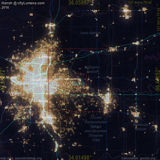
Analysis of Harrah night lights 2016
Square area 10x10 km:
 0%
0%90-99
0%80-89
1.83%70-79
1.65%60-69
5.68%50-59
5.31%40-49
6.96%30-39
10.07%20-29
8.24%10-19
29.3%0-9
30.95%Square area 50x50 km:
1.91%90-99
2.06%80-89
2.81%70-79
3.28%60-69
4.97%50-59
6.03%40-49
6.11%30-39
6.71%20-29
6.69%10-19
11.86%0-9
47.56%Clear (daylight) street map image can be seen on geolist.org.
Map coordinates:
36° 3' 35.9" North, 97° 52' 0.4" West
35° 29' 22.2" North, 97° 9' 49.1" West
34° 54' 53.9" North, 96° 27' 37.9" West
Some cities around Harrah sort by population:
• Oklahoma City
32 km =19.9 mi,  265°
265°
• Edmond
33.7 km =20.9 mi,  302°
302°
• Moore
33.7 km =20.9 mi,  240°
240°
• Midwest City
21.6 km =13.4 mi,  258°
258°
• Shawnee
28.1 km =17.5 mi,  129°
129°
• Del City
25.7 km =16 mi, 258°
• Choctaw
9.6 km =6 mi,  275°
275°
• Tecumseh
33 km =20.5 mi,  141°
141°
4538346 (p: 5,891)
Sources (retrieved 2019-11-25):
» Earth at Night: Flat Maps 2012, 2016