Hapeville night lights from space
Night Light of Hapeville (Georgia) from space (United States) Src. Average luminocity for 10x10km area is 98.6777% and for 50x50km: 83.0748%.
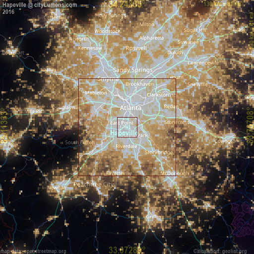
Analysis of Hapeville night lights 2016
Square area 10x10 km:
 68.5%
68.5%90-99
27.11%80-89
4.4%70-79
0%60-69
0%50-59
0%40-49
0%30-39
0%20-29
0%10-19
0%0-9
0%Square area 50x50 km:
24.1%90-99
22.35%80-89
16%70-79
15.64%60-69
11.15%50-59
5.15%40-49
3.13%30-39
1.53%20-29
0.65%10-19
0.29%0-9
0%Clear (daylight) street map image can be seen on geolist.org.
Map coordinates:
34° 14' 36.1" North, 85° 6' 48" West
33° 39' 36.4" North, 84° 24' 36.7" West
33° 4' 22.4" North, 83° 42' 25.5" West
Some cities around Hapeville sort by population:
• Atlanta
10.1 km =6.3 mi,  11°
11°
• East Point
3.5 km =2.2 mi,  308°
308°
• Forest Park
5.7 km =3.5 mi,  138°
138°
• Riverdale
9.7 km =6 mi,  181°
181°
• College Park
3.7 km =2.3 mi,  258°
258°
• Gresham Park
10.1 km =6.3 mi,  61°
61°
• Morrow
10.8 km =6.7 mi, 142°
• Conley
8 km =5 mi,  102°
102°
4199075 (p: 6,650)
Sources (retrieved 2019-11-25):
» Earth at Night: Flat Maps 2012, 2016