College Park night lights from space
Night Light of College Park (Georgia) from space (United States) Src. Average luminocity for 10x10km area is 99.2985% and for 50x50km: 80.7273%.
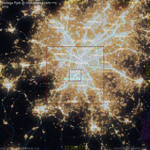
Analysis of College Park night lights 2016
Square area 10x10 km:
 68.5%
68.5%90-99
31.14%80-89
0.37%70-79
0%60-69
0%50-59
0%40-49
0%30-39
0%20-29
0%10-19
0%0-9
0%Square area 50x50 km:
23.48%90-99
21.35%80-89
15.1%70-79
14.05%60-69
12%50-59
5.33%40-49
3.26%30-39
1.78%20-29
1.29%10-19
1.49%0-9
0.87%Clear (daylight) street map image can be seen on geolist.org.
Map coordinates:
34° 14' 12.2" North, 85° 9' 9" West
33° 39' 12.4" North, 84° 26' 57.7" West
33° 3' 58.2" North, 83° 44' 46.5" West
Some cities around College Park sort by population:
• Atlanta
12 km =7.5 mi,  28°
28°
• East Point
3 km =1.9 mi,  17°
17°
• Union City
11.3 km =7 mi,  229°
229°
• Forest Park
8.2 km =5.1 mi,  115°
115°
• Riverdale
9.6 km =6 mi,  159°
159°
• Morrow
12.8 km =8 mi,  127°
127°
• Hapeville
3.7 km =2.3 mi,  78°
78°
• Conley
11.5 km =7.1 mi,  94°
94°
4188815 (p: 14,601)
Sources (retrieved 2019-11-25):
» Earth at Night: Flat Maps 2012, 2016