Groveland night lights from space
Night Light of Groveland (Massachusetts) from space (United States) Src. Average luminocity for 10x10km area is 36.8152% and for 50x50km: 31.015%.
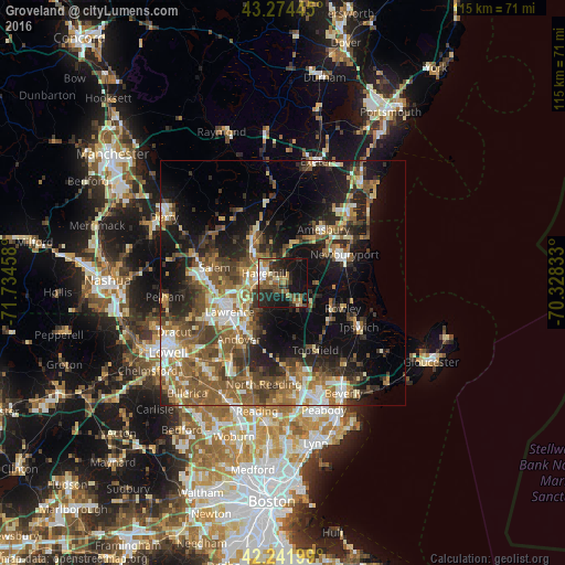
Analysis of Groveland night lights 2016
Square area 10x10 km:
 2.73%
2.73%90-99
5.45%80-89
2.73%70-79
3.33%60-69
7.73%50-59
9.09%40-49
6.36%30-39
6.97%20-29
18.94%10-19
26.97%0-9
9.7%Square area 50x50 km:
3.31%90-99
4.61%80-89
3.56%70-79
3.65%60-69
5.79%50-59
7.78%40-49
5.51%30-39
5.27%20-29
8.46%10-19
14.98%0-9
37.09%Clear (daylight) street map image can be seen on geolist.org.
Map coordinates:
43° 16' 28" North, 71° 44' 4.5" West
42° 45' 37.3" North, 71° 1' 53.2" West
42° 14' 31.2" North, 70° 19' 42" West
Some cities around Groveland sort by population:
• Lawrence
12.3 km =7.6 mi,  241°
241°
• Haverhill
4.1 km =2.5 mi,  295°
295°
• Methuen
13.6 km =8.5 mi,  253°
253°
• North Andover
10.9 km =6.8 mi,  230°
230°
• Amesbury
13.7 km =8.5 mi,  37°
37°
• Plaistow
9.9 km =6.2 mi,  328°
328°
• Atkinson
12.8 km =8 mi,  312°
312°
• Merrimac
8.2 km =5.1 mi,  16°
16°
4938501 (p: 6,143)
Sources (retrieved 2019-11-25):
» Earth at Night: Flat Maps 2012, 2016