Merrimac night lights from space
Night Light of Merrimac (Massachusetts) from space (United States) Src. Average luminocity for 10x10km area is 21.6697% and for 50x50km: 23.0442%.
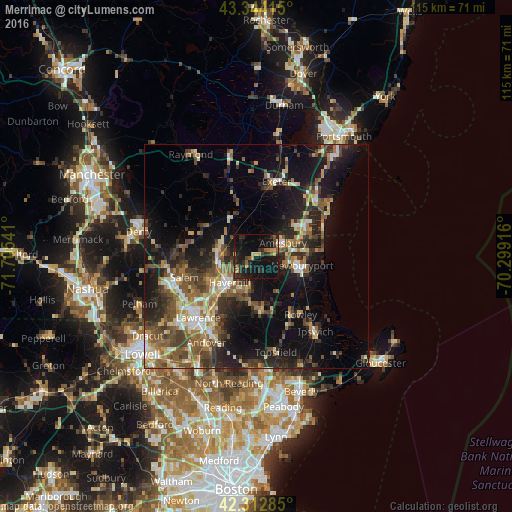
Analysis of Merrimac night lights 2016
Square area 10x10 km:
 0%
0%90-99
0.61%80-89
2.42%70-79
3.03%60-69
1.52%50-59
5.15%40-49
1.67%30-39
5.45%20-29
13.79%10-19
40.61%0-9
25.76%Square area 50x50 km:
2.06%90-99
3.01%80-89
2.62%70-79
2.68%60-69
3.33%50-59
4.92%40-49
4.38%30-39
4.48%20-29
7.91%10-19
16.36%0-9
48.25%Clear (daylight) street map image can be seen on geolist.org.
Map coordinates:
43° 20' 38.9" North, 71° 42' 19.5" West
42° 49' 50.3" North, 71° 0' 8.2" West
42° 18' 46.3" North, 70° 17' 57" West
Some cities around Merrimac sort by population:
• Haverhill
8.6 km =5.3 mi,  225°
225°
• Amesbury
6.6 km =4.1 mi,  62°
62°
• Newburyport
10.4 km =6.5 mi,  101°
101°
• Seabrook
12.8 km =8 mi, 56°
• Plaistow
7.6 km =4.7 mi,  274°
274°
• Atkinson
11.8 km =7.3 mi, 274°
• Kingston
12.5 km =7.8 mi,  340°
340°
• Groveland
8.2 km =5.1 mi,  196°
196°
4943784 (p: 6,245)
Sources (retrieved 2019-11-25):
» Earth at Night: Flat Maps 2012, 2016