Amesbury night lights from space
Night Light of Amesbury (Massachusetts) from space (United States) Src. Average luminocity for 10x10km area is 40.2048% and for 50x50km: 19.4659%.
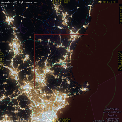
Analysis of Amesbury night lights 2016
Square area 10x10 km:
 3.33%
3.33%90-99
6.03%80-89
6.98%70-79
6.03%60-69
6.83%50-59
7.94%40-49
4.76%30-39
6.51%20-29
16.35%10-19
20.95%0-9
14.29%Square area 50x50 km:
1.86%90-99
2.73%80-89
2.27%70-79
2.05%60-69
2.94%50-59
4.02%40-49
3.39%30-39
3.43%20-29
6.01%10-19
13.85%0-9
57.45%Clear (daylight) street map image can be seen on geolist.org.
Map coordinates:
43° 22' 18" North, 71° 37' 59.4" West
42° 51' 30.3" North, 70° 55' 48.2" West
42° 20' 27.1" North, 70° 13' 36.9" West
Some cities around Amesbury sort by population:
• Newburyport
6.7 km =4.2 mi,  139°
139°
• Hampton
11.5 km =7.1 mi,  40°
40°
• Exeter
13.8 km =8.6 mi,  353°
353°
• Seabrook
6.3 km =3.9 mi,  49°
49°
• Plaistow
13.6 km =8.5 mi,  259°
259°
• Merrimac
6.6 km =4.1 mi,  242°
242°
• Kingston
13.3 km =8.3 mi,  310°
310°
• Groveland
13.7 km =8.5 mi,  217°
217°
4929004 (p: 18,313)
Sources (retrieved 2019-11-25):
» Earth at Night: Flat Maps 2012, 2016