Granite City night lights from space
Night Light of Granite City (Illinois) from space (United States) Src. Average luminocity for 10x10km area is 82.3231% and for 50x50km: 66.2924%.

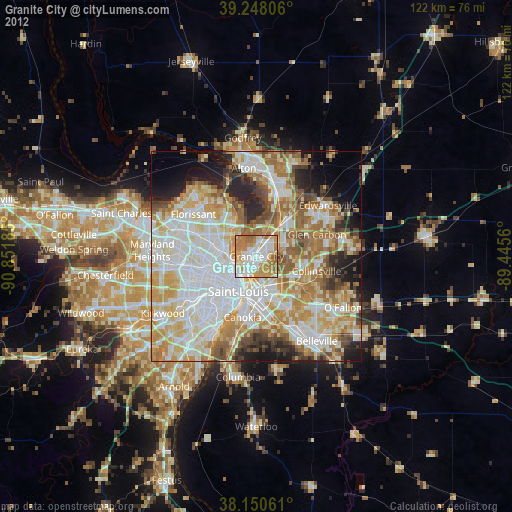
Analysis of Granite City night lights 2016
Square area 10x10 km:
 23.47%
90-99
21.6%80-89
6.97%70-79
17.52%60-69
19.9%50-59
9.52%40-49
1.02%30-39
0%20-29
0%10-19
0%0-9
0%Square area 50x50 km:
18.39%90-99
16.02%80-89
9.77%70-79
9.75%60-69
9.38%50-59
7.85%40-49
5.42%30-39
4.4%20-29
6.62%10-19
5.3%0-9
7.1%Clear (daylight) street map image can be seen on geolist.org.
Map coordinates:
39° 14' 53" North, 90° 51' 6.7" West
38° 42' 5.2" North, 90° 8' 55.4" West
38° 9' 2.2" North, 89° 26' 44.2" West
Some cities around Granite City sort by population:
• St. Louis
9.3 km =5.8 mi,  207°
207°
• East Saint Louis
8.6 km =5.3 mi,  181°
181°
• Spanish Lake
11.2 km =7 mi,  328°
328°
• Jennings
9.9 km =6.2 mi,  281°
281°
• Bellefontaine Neighbors
8 km =5 mi,  302°
302°
• Pontoon Beach
6.8 km =4.2 mi,  60°
60°
• Glasgow Village
7.2 km =4.5 mi,  323°
323°
• Dellwood
13 km =8.1 mi,  294°
294°
4239714 (p: 29,054)
Sources (retrieved 2019-11-25):
» Earth at Night: Flat Maps 2012, 2016