Glendale night lights from space
Night Light of Glendale (Missouri) from space (United States) Src. Average luminocity for 10x10km area is 90.0828% and for 50x50km: 67.3478%.
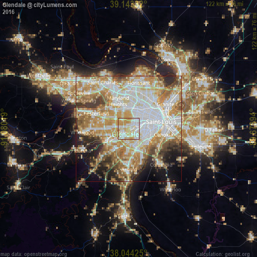
Analysis of Glendale night lights 2016
Square area 10x10 km:
 28.57%
90-99
27.6%80-89
23.21%70-79
19.32%60-69
1.3%50-59
0%40-49
0%30-39
0%20-29
0%10-19
0%0-9
0%Square area 50x50 km:
18.7%90-99
15.68%80-89
9.37%70-79
12.25%60-69
9.7%50-59
6.72%40-49
4.54%30-39
5.16%20-29
5.56%10-19
6.83%0-9
5.48%Clear (daylight) street map image can be seen on geolist.org.
Map coordinates:
39° 8' 36" North, 91° 4' 48.7" West
38° 35' 45.2" North, 90° 22' 37.4" West
38° 2' 39.3" North, 89° 40' 26.2" West
Some cities around Glendale sort by population:
• Kirkwood
2.9 km =1.8 mi,  241°
241°
• Webster Groves
1.8 km =1.1 mi,  102°
102°
• Crestwood
4.3 km =2.7 mi,  185°
185°
• Ladue
6 km =3.7 mi,  357°
357°
• Des Peres
4.9 km =3 mi,  276°
276°
• Brentwood
3.4 km =2.1 mi,  45°
45°
• Maplewood
4.9 km =3 mi,  67°
67°
• Shrewsbury
3.6 km =2.2 mi, 100°
4388036 (p: 5,927)
Sources (retrieved 2019-11-25):
» Earth at Night: Flat Maps 2012, 2016