Des Peres night lights from space
Night Light of Des Peres (Missouri) from space (United States) Src. Average luminocity for 10x10km area is 83.9821% and for 50x50km: 65.5324%.
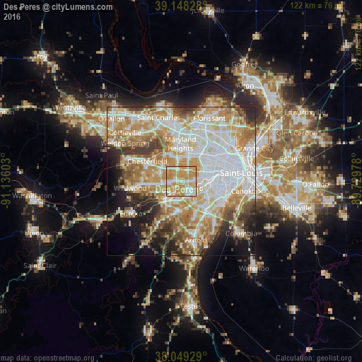
Analysis of Des Peres night lights 2016
Square area 10x10 km:
 16.88%
90-99
19.64%80-89
13.15%70-79
44.32%60-69
6.01%50-59
0%40-49
0%30-39
0%20-29
0%10-19
0%0-9
0%Square area 50x50 km:
17.93%90-99
14.98%80-89
9.26%70-79
12.06%60-69
9.62%50-59
6.54%40-49
4.25%30-39
5.01%20-29
5.9%10-19
7.84%0-9
6.61%Clear (daylight) street map image can be seen on geolist.org.
Map coordinates:
39° 8' 53.8" North, 91° 8' 9.7" West
38° 36' 3.2" North, 90° 25' 58.4" West
38° 2' 57.4" North, 89° 43' 47.2" West
Some cities around Des Peres sort by population:
• Kirkwood
3 km =1.9 mi,  130°
130°
• Webster Groves
6.6 km =4.1 mi,  98°
98°
• Creve Coeur
6.7 km =4.2 mi,  7°
7°
• Manchester
6.7 km =4.2 mi,  266°
266°
• Crestwood
6.6 km =4.1 mi,  137°
137°
• Town and Country
2.9 km =1.8 mi,  295°
295°
• Ladue
7.1 km =4.4 mi,  39°
39°
• Glendale
4.9 km =3 mi, 96°
4383778 (p: 8,572)
Sources (retrieved 2019-11-25):
» Earth at Night: Flat Maps 2012, 2016