Crestwood night lights from space
Night Light of Crestwood (Missouri) from space (United States) Src. Average luminocity for 10x10km area is 88.7094% and for 50x50km: 62.9872%.
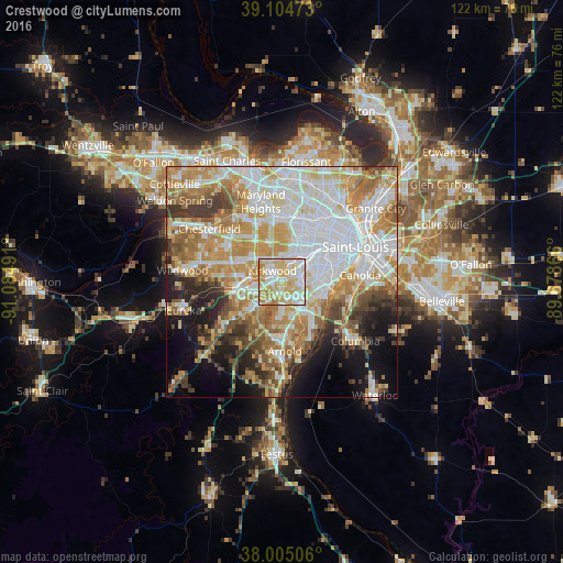
Analysis of Crestwood night lights 2016
Square area 10x10 km:
 21.1%
21.1%90-99
28.08%80-89
28.9%70-79
16.4%60-69
5.52%50-59
0%40-49
0%30-39
0%20-29
0%10-19
0%0-9
0%Square area 50x50 km:
17.61%90-99
14.16%80-89
8.62%70-79
11.33%60-69
8.85%50-59
6.59%40-49
4.28%30-39
5.1%20-29
5.3%10-19
8.24%0-9
9.92%Clear (daylight) street map image can be seen on geolist.org.
Map coordinates:
39° 6' 17" North, 91° 5' 5.7" West
38° 33' 25.2" North, 90° 22' 54.4" West
38° 0' 18.2" North, 89° 40' 43.2" West
Some cities around Crestwood sort by population:
• Kirkwood
3.7 km =2.3 mi,  323°
323°
• Webster Groves
4.5 km =2.8 mi,  28°
28°
• Affton
4.3 km =2.7 mi,  99°
99°
• Concord
4.2 km =2.6 mi,  149°
149°
• Sunset Hills
3 km =1.9 mi,  227°
227°
• Sappington
2.2 km =1.4 mi,  175°
175°
• Shrewsbury
5.4 km =3.4 mi,  46°
46°
• Glendale
4.3 km =2.7 mi,  5°
5°
4382833 (p: 11,966)
Sources (retrieved 2019-11-25):
» Earth at Night: Flat Maps 2012, 2016