Maplewood night lights from space
Night Light of Maplewood (Missouri) from space (United States) Src. Average luminocity for 10x10km area is 95.7435% and for 50x50km: 69.1108%.
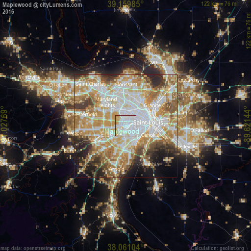
Analysis of Maplewood night lights 2016
Square area 10x10 km:
 62.99%
90-99
17.05%80-89
13.64%70-79
6.33%60-69
0%50-59
0%40-49
0%30-39
0%20-29
0%10-19
0%0-9
0%Square area 50x50 km:
19.04%90-99
16.24%80-89
9.55%70-79
12.73%60-69
10%50-59
7.15%40-49
4.74%30-39
5.15%20-29
6.03%10-19
5.93%0-9
3.44%Clear (daylight) street map image can be seen on geolist.org.
Map coordinates:
39° 9' 35.5" North, 91° 1' 39.7" West
38° 36' 45.2" North, 90° 19' 28.4" West
38° 3' 39.7" North, 89° 37' 17.2" West
Some cities around Maplewood sort by population:
• University City
5 km =3.1 mi,  15°
15°
• Webster Groves
3.6 km =2.2 mi,  232°
232°
• Clayton
3.3 km =2.1 mi,  1°
1°
• Ladue
6.4 km =4 mi,  310°
310°
• Richmond Heights
1.8 km =1.1 mi,  13°
13°
• Brentwood
2.2 km =1.4 mi,  284°
284°
• Shrewsbury
2.7 km =1.7 mi,  203°
203°
• Glendale
4.9 km =3 mi,  247°
247°
4397042 (p: 7,945)
Sources (retrieved 2019-11-25):
» Earth at Night: Flat Maps 2012, 2016