Ladue night lights from space
Night Light of Ladue (Missouri) from space (United States) Src. Average luminocity for 10x10km area is 89.2289% and for 50x50km: 68.4866%.
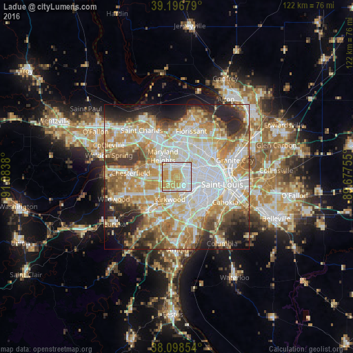
Analysis of Ladue night lights 2016
Square area 10x10 km:
 31.17%
90-99
25%80-89
10.55%70-79
32.63%60-69
0.65%50-59
0%40-49
0%30-39
0%20-29
0%10-19
0%0-9
0%Square area 50x50 km:
18.75%90-99
15.87%80-89
9.61%70-79
12.33%60-69
10%50-59
6.56%40-49
4.78%30-39
5.39%20-29
8.02%10-19
6.38%0-9
2.31%Clear (daylight) street map image can be seen on geolist.org.
Map coordinates:
39° 11' 48.4" North, 91° 5' 1.7" West
38° 38' 59.2" North, 90° 22' 50.4" West
38° 5' 54.7" North, 89° 40' 39.2" West
Some cities around Ladue sort by population:
• University City
6.2 km =3.9 mi,  83°
83°
• Creve Coeur
3.8 km =2.4 mi,  288°
288°
• Overland
5.9 km =3.7 mi,  15°
15°
• Clayton
5 km =3.1 mi,  99°
99°
• Richmond Heights
5.8 km =3.6 mi,  113°
113°
• Brentwood
4.5 km =2.8 mi,  142°
142°
• Olivette
1.8 km =1.1 mi,  13°
13°
• Glendale
6 km =3.7 mi,  177°
177°
4394084 (p: 8,597)
Sources (retrieved 2019-11-25):
» Earth at Night: Flat Maps 2012, 2016