Brentwood night lights from space
Night Light of Brentwood (Missouri) from space (United States) Src. Average luminocity for 10x10km area is 92.3912% and for 50x50km: 69.2856%.
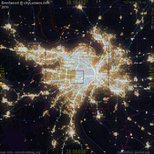
Analysis of Brentwood night lights 2016
Square area 10x10 km:
 45.78%
90-99
20.62%80-89
16.4%70-79
16.72%60-69
0.49%50-59
0%40-49
0%30-39
0%20-29
0%10-19
0%0-9
0%Square area 50x50 km:
18.98%90-99
16.27%80-89
9.59%70-79
12.65%60-69
10.16%50-59
6.88%40-49
4.9%30-39
5.31%20-29
6.76%10-19
5.79%0-9
2.72%Clear (daylight) street map image can be seen on geolist.org.
Map coordinates:
39° 9' 53.4" North, 91° 3' 8.7" West
38° 37' 3.2" North, 90° 20' 57.4" West
38° 3' 57.9" North, 89° 38' 46.2" West
Some cities around Brentwood sort by population:
• University City
5.5 km =3.4 mi,  39°
39°
• Webster Groves
2.9 km =1.8 mi,  194°
194°
• Clayton
3.6 km =2.2 mi, 38°
• Ladue
4.5 km =2.8 mi,  322°
322°
• Richmond Heights
2.9 km =1.8 mi,  64°
64°
• Maplewood
2.2 km =1.4 mi,  104°
104°
• Shrewsbury
3.2 km =2 mi,  160°
160°
• Glendale
3.4 km =2.1 mi,  225°
225°
4378312 (p: 8,057)
Sources (retrieved 2019-11-25):
» Earth at Night: Flat Maps 2012, 2016