Round Lake night lights from space
Night Light of Round Lake (Illinois) from space (United States) Src. Average luminocity for 10x10km area is 61.6937% and for 50x50km: 50.4491%.
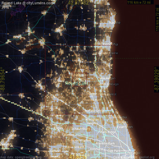
Analysis of Round Lake night lights 2016
Square area 10x10 km:
 2.86%
2.86%90-99
6.19%80-89
10.79%70-79
12.22%60-69
16.67%50-59
24.92%40-49
13.33%30-39
11.75%20-29
1.27%10-19
0%0-9
0%Square area 50x50 km:
6.03%90-99
6.86%80-89
6%70-79
7.43%60-69
12.31%50-59
13.43%40-49
11.31%30-39
7.77%20-29
8.95%10-19
10.96%0-9
8.96%Clear (daylight) street map image can be seen on geolist.org.
Map coordinates:
42° 52' 15" North, 88° 47' 47.5" West
42° 21' 12.1" North, 88° 5' 36.3" West
41° 49' 53.8" North, 87° 23' 25" West
Some cities around Round Lake sort by population:
• Grayslake
4.4 km =2.7 mi,  103°
103°
• Lindenhurst
8.4 km =5.2 mi,  40°
40°
• Wauconda
11.2 km =7 mi,  199°
199°
• Fox Lake
8.8 km =5.5 mi,  303°
303°
• Gages Lake
9.1 km =5.7 mi,  91°
91°
• Lake Villa
7.3 km =4.5 mi,  12°
12°
• Lakemoor
9.1 km =5.7 mi,  252°
252°
• Grandwood Park
9.8 km =6.1 mi,  63°
63°
4908236 (p: 18,461)
Sources (retrieved 2019-11-25):
» Earth at Night: Flat Maps 2012, 2016