Lindenhurst night lights from space
Night Light of Lindenhurst (Illinois) from space (United States) Src. Average luminocity for 10x10km area is 55.3365% and for 50x50km: 42.5872%.
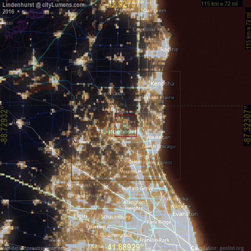
Analysis of Lindenhurst night lights 2016
Square area 10x10 km:
 3.97%
3.97%90-99
8.41%80-89
4.13%70-79
7.62%60-69
10.48%50-59
25.56%40-49
12.06%30-39
13.02%20-29
14.29%10-19
0.48%0-9
0%Square area 50x50 km:
5.11%90-99
5.78%80-89
4.91%70-79
6.02%60-69
9.53%50-59
10.83%40-49
9.54%30-39
7.05%20-29
9.04%10-19
11.45%0-9
20.73%Clear (daylight) street map image can be seen on geolist.org.
Map coordinates:
42° 55' 39.3" North, 88° 43' 45.6" West
42° 24' 38.1" North, 88° 1' 34.3" West
41° 53' 21.4" North, 87° 19' 23.1" West
Some cities around Lindenhurst sort by population:
• Round Lake Beach
6.8 km =4.2 mi,  230°
230°
• Grayslake
7.5 km =4.7 mi,  189°
189°
• Round Lake
8.4 km =5.2 mi,  220°
220°
• Antioch
9.3 km =5.8 mi,  322°
322°
• Gages Lake
7.5 km =4.7 mi,  151°
151°
• Lake Villa
4 km =2.5 mi,  280°
280°
• Round Lake Park
7.3 km =4.5 mi,  214°
214°
• Grandwood Park
3.8 km =2.4 mi,  120°
120°
4900013 (p: 14,408)
Sources (retrieved 2019-11-25):
» Earth at Night: Flat Maps 2012, 2016