Fruitridge Pocket night lights from space
Night Light of Fruitridge Pocket (California) from space (United States) Src. Average luminocity for 10x10km area is 96.0422% and for 50x50km: 38.5341%.
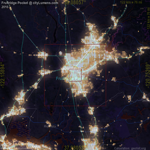
Analysis of Fruitridge Pocket night lights 2016
Square area 10x10 km:
 43.51%
90-99
40.91%80-89
11.04%70-79
3.9%60-69
0.65%50-59
0%40-49
0%30-39
0%20-29
0%10-19
0%0-9
0%Square area 50x50 km:
8.84%90-99
9.88%80-89
4.72%70-79
6.95%60-69
5.56%50-59
3.46%40-49
2.82%30-39
3.07%20-29
4.5%10-19
9.15%0-9
41.07%Clear (daylight) street map image can be seen on geolist.org.
Map coordinates:
39° 4' 50.1" North, 122° 9' 32.2" West
38° 31' 57.5" North, 121° 27' 20.9" West
37° 58' 49.9" North, 120° 45' 9.7" West
Some cities around Fruitridge Pocket sort by population:
• Sacramento
6.4 km =4 mi,  328°
328°
• Arden-Arcade
10.3 km =6.4 mi,  40°
40°
• West Sacramento
8.4 km =5.2 mi,  309°
309°
• Florin
5.8 km =3.6 mi,  134°
134°
• Vineyard
12.1 km =7.5 mi, 128°
• Rosemont
8.2 km =5.1 mi,  74°
74°
• Parkway
4.1 km =2.5 mi,  183°
183°
• La Riviera
9.4 km =5.8 mi, 66°
7315196 (p: 5,800)
Sources (retrieved 2019-11-25):
» Earth at Night: Flat Maps 2012, 2016