Parkway night lights from space
Night Light of Parkway (California) from space (United States) Src. Average luminocity for 10x10km area is 89.9432% and for 50x50km: 36.4497%.
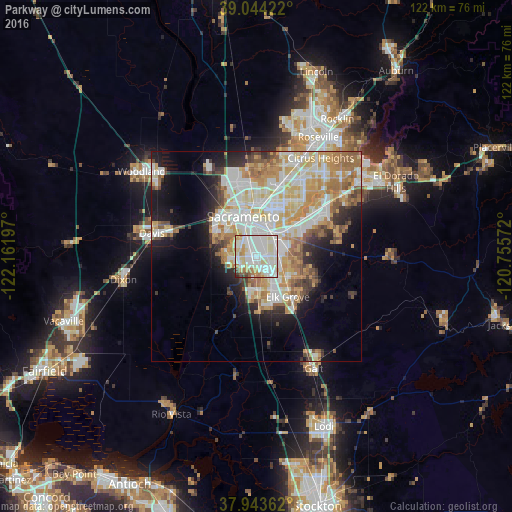
Analysis of Parkway night lights 2016
Square area 10x10 km:
 33.77%
90-99
35.39%80-89
12.34%70-79
6.66%60-69
5.84%50-59
2.27%40-49
1.95%30-39
1.3%20-29
0.49%10-19
0%0-9
0%Square area 50x50 km:
8.31%90-99
9.47%80-89
4.56%70-79
6.49%60-69
5.17%50-59
3.13%40-49
2.71%30-39
2.91%20-29
4.19%10-19
8.81%0-9
44.25%Clear (daylight) street map image can be seen on geolist.org.
Map coordinates:
39° 2' 39.2" North, 122° 9' 43.1" West
38° 29' 45.7" North, 121° 27' 31.8" West
37° 56' 37" North, 120° 45' 20.6" West
Some cities around Parkway sort by population:
• Sacramento
10 km =6.2 mi,  341°
341°
• West Sacramento
11.3 km =7 mi,  326°
326°
• Florin
4.4 km =2.7 mi,  90°
90°
• Laguna
8.9 km =5.5 mi,  159°
159°
• Vineyard
10.4 km =6.5 mi,  109°
109°
• Rosemont
10.3 km =6.4 mi,  52°
52°
• La Riviera
11.9 km =7.4 mi, 48°
• Fruitridge Pocket
4.1 km =2.5 mi,  3°
3°
5381305 (p: 14,670)
Sources (retrieved 2019-11-25):
» Earth at Night: Flat Maps 2012, 2016