White Oak night lights from space
Night Light of White Oak (Maryland) from space (United States) Src. Average luminocity for 10x10km area is 87.7532% and for 50x50km: 76.5788%.
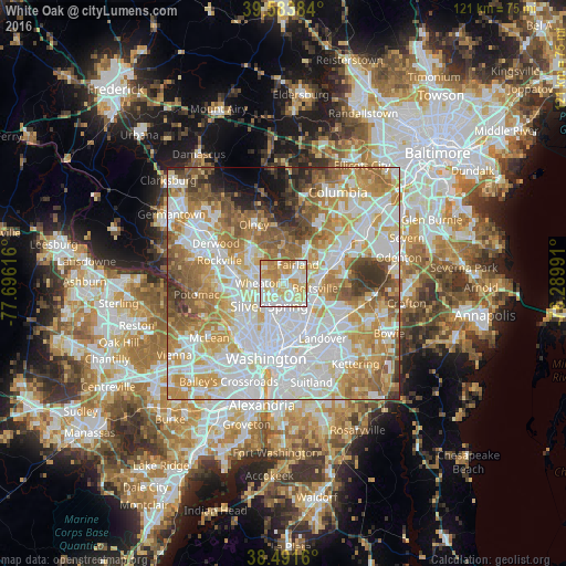
Analysis of White Oak night lights 2016
Square area 10x10 km:
 24.19%
90-99
26.62%80-89
20.29%70-79
18.83%60-69
9.9%50-59
0.16%40-49
0%30-39
0%20-29
0%10-19
0%0-9
0%Square area 50x50 km:
24.25%90-99
18.83%80-89
10.46%70-79
12.88%60-69
10.47%50-59
8%40-49
4.72%30-39
3.91%20-29
2.62%10-19
2.42%0-9
1.44%Clear (daylight) street map image can be seen on geolist.org.
Map coordinates:
39° 35' 1.8" North, 77° 41' 46.2" West
39° 2' 23.4" North, 76° 59' 34.9" West
38° 29' 29.8" North, 76° 17' 23.7" West
Some cities around White Oak sort by population:
• Fairland
5.1 km =3.2 mi,  36°
36°
• Calverton
5.3 km =3.3 mi,  68°
68°
• Adelphi
4.5 km =2.8 mi,  155°
155°
• Colesville
4.1 km =2.5 mi,  349°
349°
• Glenmont
5.3 km =3.3 mi,  292°
292°
• Kemp Mill
2.3 km =1.4 mi,  267°
267°
• Four Corners
2.8 km =1.7 mi,  218°
218°
• Hillandale
2.2 km =1.4 mi,  132°
132°
4373449 (p: 17,403)
Sources (retrieved 2019-11-25):
» Earth at Night: Flat Maps 2012, 2016