Hillandale night lights from space
Night Light of Hillandale (Maryland) from space (United States) Src. Average luminocity for 10x10km area is 90.2792% and for 50x50km: 77.5928%.
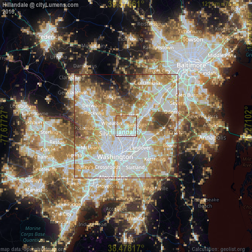
Analysis of Hillandale night lights 2016
Square area 10x10 km:
 30.52%
90-99
27.27%80-89
22.89%70-79
15.1%60-69
4.22%50-59
0%40-49
0%30-39
0%20-29
0%10-19
0%0-9
0%Square area 50x50 km:
25.01%90-99
19.61%80-89
10.67%70-79
12.94%60-69
10.01%50-59
7.71%40-49
4.3%30-39
3.77%20-29
2.58%10-19
2.46%0-9
0.95%Clear (daylight) street map image can be seen on geolist.org.
Map coordinates:
39° 34' 14.2" North, 77° 40' 38.2" West
39° 1' 35.4" North, 76° 58' 26.9" West
38° 28' 41.4" North, 76° 16' 15.7" West
Some cities around Hillandale sort by population:
• Fairland
5.7 km =3.5 mi,  14°
14°
• Langley Park
4.2 km =2.6 mi,  188°
188°
• Calverton
4.8 km =3 mi,  43°
43°
• White Oak
2.2 km =1.4 mi,  312°
312°
• Beltsville
5.8 km =3.6 mi,  80°
80°
• Adelphi
2.6 km =1.6 mi,  175°
175°
• Kemp Mill
4.1 km =2.5 mi,  289°
289°
• Four Corners
3.4 km =2.1 mi,  258°
258°
4358066 (p: 6,043)
Sources (retrieved 2019-11-25):
» Earth at Night: Flat Maps 2012, 2016