Fort Morgan night lights from space
Night Light of Fort Morgan (Colorado) from space (United States) Src. Average luminocity for 10x10km area is 21.4724% and for 50x50km: 1.5833%.
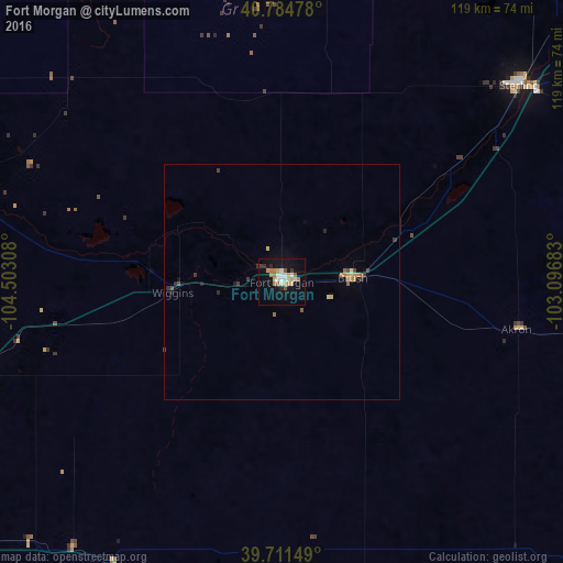
Analysis of Fort Morgan night lights 2016
Square area 10x10 km:
 3.08%
3.08%90-99
3.41%80-89
2.6%70-79
3.73%60-69
3.57%50-59
1.62%40-49
0.81%30-39
2.11%20-29
1.46%10-19
20.29%0-9
57.31%Square area 50x50 km:
0.12%90-99
0.16%80-89
0.26%70-79
0.23%60-69
0.27%50-59
0.16%40-49
0.16%30-39
0.31%20-29
0.17%10-19
0.93%0-9
97.23%Clear (daylight) street map image can be seen on geolist.org.
Map coordinates:
40° 47' 5.2" North, 104° 30' 11.1" West
40° 15' 0.9" North, 103° 47' 59.8" West
39° 42' 41.4" North, 103° 5' 48.6" West
Some cities around Fort Morgan sort by population:
• Greeley
79.4 km =49.3 mi,  284°
284°
• Brighton
91.6 km =56.9 mi,  251°
251°
• Evans
76.9 km =47.8 mi, 280°
• Johnstown
94.8 km =58.9 mi, 275°
• Sterling
65.2 km =40.5 mi,  50°
50°
• Milliken
89.9 km =55.9 mi, 275°
• Brush
15 km =9.3 mi,  86°
86°
• Lochbuie
82.4 km =51.2 mi, 250°
5577158 (p: 11,319)
Sources (retrieved 2019-11-25):
» Earth at Night: Flat Maps 2012, 2016