Fort Dix night lights from space
Night Light of Fort Dix (New Jersey) from space (United States) Src. Average luminocity for 10x10km area is 45.1282% and for 50x50km: 35.2268%.
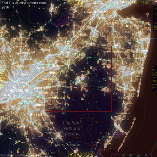
Analysis of Fort Dix night lights 2016
Square area 10x10 km:
 6.17%
6.17%90-99
7.14%80-89
7.95%70-79
8.6%60-69
4.22%50-59
3.73%40-49
6.17%30-39
7.79%20-29
17.69%10-19
30.52%0-9
0%Square area 50x50 km:
4.59%90-99
4.88%80-89
5.33%70-79
6.47%60-69
6.97%50-59
5.89%40-49
5.29%30-39
5.38%20-29
7.16%10-19
15.38%0-9
32.66%Clear (daylight) street map image can be seen on geolist.org.
Map coordinates:
40° 33' 58" North, 75° 19' 17.8" West
40° 1' 47.4" North, 74° 37' 6.6" West
39° 29' 21.6" North, 73° 54' 55.3" West
Some cities around Fort Dix sort by population:
• Willingboro
21.3 km =13.2 mi,  269°
269°
• Vincentown
15.4 km =9.6 mi,  226°
226°
• Browns Mills
7 km =4.3 mi,  154°
154°
• Mount Holly
15 km =9.3 mi,  254°
254°
• Burlington
21.5 km =13.4 mi,  282°
282°
• Bristol
21.4 km =13.3 mi,  291°
291°
• White Horse
19.3 km =12 mi,  338°
338°
• Yardville
17.3 km =10.7 mi,  346°
346°
5098132 (p: 7,716)
Sources (retrieved 2019-11-25):
» Earth at Night: Flat Maps 2012, 2016