Burlington night lights from space
Night Light of Burlington (New Jersey) from space (United States) Src. Average luminocity for 10x10km area is 85.7971% and for 50x50km: 66.0796%.
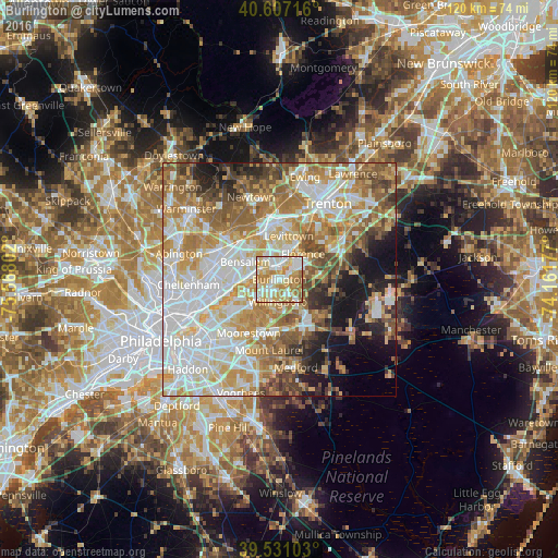
Analysis of Burlington night lights 2016
Square area 10x10 km:
 20.62%
90-99
24.03%80-89
21.43%70-79
19.97%60-69
10.88%50-59
3.08%40-49
0%30-39
0%20-29
0%10-19
0%0-9
0%Square area 50x50 km:
17.51%90-99
14.55%80-89
10.01%70-79
11.33%60-69
10.73%50-59
7.92%40-49
5.73%30-39
3.8%20-29
4.49%10-19
8.59%0-9
5.35%Clear (daylight) street map image can be seen on geolist.org.
Map coordinates:
40° 36' 25.8" North, 75° 34' 4.9" West
40° 4' 16.4" North, 74° 51' 53.6" West
39° 31' 51.7" North, 74° 9' 42.4" West
Some cities around Burlington sort by population:
• Levittown
9.8 km =6.1 mi,  18°
18°
• Willingboro
4.8 km =3 mi,  184°
184°
• Cinnaminson
13.7 km =8.5 mi,  232°
232°
• Mount Holly
10.9 km =6.8 mi,  142°
142°
• Croydon
3.7 km =2.3 mi,  298°
298°
• Bristol
3.5 km =2.2 mi, 18°
• Fairless Hills
12.1 km =7.5 mi,  3°
3°
• Edgewater Park
3.1 km =1.9 mi,  263°
263°
5096075 (p: 9,808)
Sources (retrieved 2019-11-25):
» Earth at Night: Flat Maps 2012, 2016