Bristol night lights from space
Night Light of Bristol (Pennsylvania) from space (United States) Src. Average luminocity for 10x10km area is 85.7873% and for 50x50km: 64.3711%.
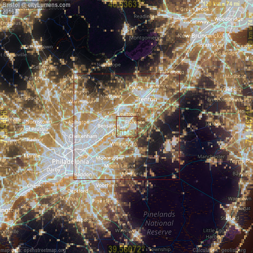
Analysis of Bristol night lights 2016
Square area 10x10 km:
 23.7%
23.7%90-99
24.35%80-89
19.97%70-79
18.67%60-69
6.33%50-59
4.87%40-49
2.11%30-39
0%20-29
0%10-19
0%0-9
0%Square area 50x50 km:
15.9%90-99
13.85%80-89
9.59%70-79
10.94%60-69
10.86%50-59
8.57%40-49
5.93%30-39
4.68%20-29
5.27%10-19
9.91%0-9
4.49%Clear (daylight) street map image can be seen on geolist.org.
Map coordinates:
40° 38' 10.9" North, 75° 33' 17.9" West
40° 6' 2.4" North, 74° 51' 6.6" West
39° 33' 38.6" North, 74° 8' 55.4" West
Some cities around Bristol sort by population:
• Levittown
6.4 km =4 mi,  17°
17°
• Willingboro
8.2 km =5.1 mi,  190°
190°
• Mount Holly
13.2 km =8.2 mi,  155°
155°
• Croydon
4.6 km =2.9 mi,  251°
251°
• Burlington
3.5 km =2.2 mi,  198°
198°
• Morrisville
13.5 km =8.4 mi, 23°
• Fairless Hills
8.8 km =5.5 mi,  358°
358°
• Edgewater Park
5.5 km =3.4 mi,  229°
229°
5181688 (p: 9,569)
Sources (retrieved 2019-11-25):
» Earth at Night: Flat Maps 2012, 2016