Browns Mills night lights from space
Night Light of Browns Mills (New Jersey) from space (United States) Src. Average luminocity for 10x10km area is 33.4048% and for 50x50km: 25.9181%.
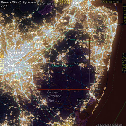
Analysis of Browns Mills night lights 2016
Square area 10x10 km:
 2.89%
2.89%90-99
1.87%80-89
5.44%70-79
3.91%60-69
4.59%50-59
6.97%40-49
7.65%30-39
7.31%20-29
16.33%10-19
26.19%0-9
16.84%Square area 50x50 km:
2.39%90-99
2.73%80-89
4.22%70-79
4.39%60-69
4.72%50-59
4.85%40-49
4.93%30-39
4.52%20-29
7.03%10-19
14.81%0-9
45.42%Clear (daylight) street map image can be seen on geolist.org.
Map coordinates:
40° 30' 33.6" North, 75° 17' 9.8" West
39° 58' 21.4" North, 74° 34' 58.5" West
39° 25' 53.9" North, 73° 52' 47.3" West
Some cities around Browns Mills sort by population:
• Willingboro
25.1 km =15.6 mi,  284°
284°
• Vincentown
14.7 km =9.1 mi,  253°
253°
• Holiday City-Berkeley
26 km =16.2 mi,  92°
92°
• Mount Holly
17.6 km =10.9 mi, 277°
• White Horse
26.3 km =16.3 mi,  337°
337°
• Crestwood Village
19.1 km =11.9 mi,  98°
98°
• Fort Dix
7 km =4.3 mi,  334°
334°
• Yardville
24.2 km =15 mi, 343°
4500959 (p: 11,223)
Sources (retrieved 2019-11-25):
» Earth at Night: Flat Maps 2012, 2016