Forest City night lights from space
Night Light of Forest City (North Carolina) from space (United States) Src. Average luminocity for 10x10km area is 47.6886% and for 50x50km: 8.8917%.
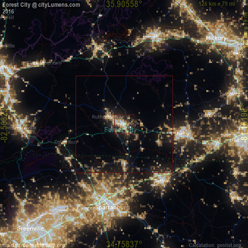
Analysis of Forest City night lights 2016
Square area 10x10 km:
 5.86%
5.86%90-99
6.59%80-89
7.33%70-79
8.42%60-69
8.97%50-59
3.3%40-49
9.52%30-39
10.26%20-29
21.61%10-19
15.93%0-9
2.2%Square area 50x50 km:
0.35%90-99
0.41%80-89
1.08%70-79
0.84%60-69
1.59%50-59
1.28%40-49
1.69%30-39
2.61%20-29
3.29%10-19
9.42%0-9
77.44%Clear (daylight) street map image can be seen on geolist.org.
Map coordinates:
35° 54' 20.1" North, 82° 34' 5.6" West
35° 20' 2.4" North, 81° 51' 54.4" West
34° 45' 30.1" North, 81° 9' 43.1" West
Some cities around Forest City sort by population:
• Spartanburg
43.2 km =26.8 mi,  188°
188°
• Shelby
30.2 km =18.8 mi,  98°
98°
• Morganton
48.6 km =30.2 mi,  19°
19°
• Gaffney
35.1 km =21.8 mi,  146°
146°
• Boiling Springs
33.7 km =20.9 mi,  198°
198°
• Marion
41 km =25.5 mi,  341°
341°
• Valley Falls
36.7 km =22.8 mi, 195°
• Cherryville
44.4 km =27.6 mi,  83°
83°
4466720 (p: 7,282)
Sources (retrieved 2019-11-25):
» Earth at Night: Flat Maps 2012, 2016