Marion night lights from space
Night Light of Marion (North Carolina) from space (United States) Src. Average luminocity for 10x10km area is 36.958% and for 50x50km: 4.9058%.
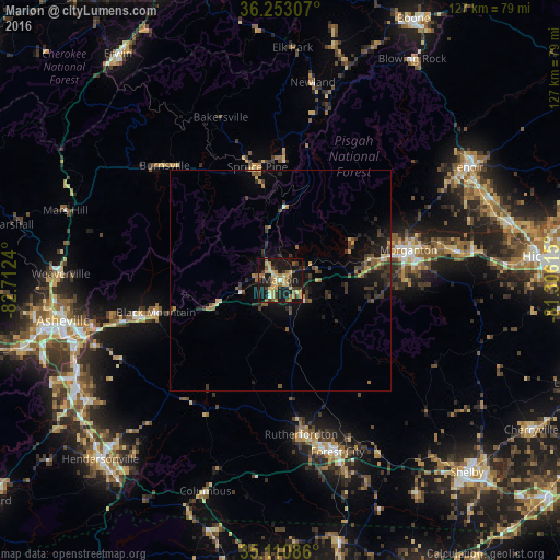
Analysis of Marion night lights 2016
Square area 10x10 km:
 0.7%
0.7%90-99
0.7%80-89
11.89%70-79
7.87%60-69
6.64%50-59
5.94%40-49
2.62%30-39
9.09%20-29
5.07%10-19
43.71%0-9
5.77%Square area 50x50 km:
0.12%90-99
0.08%80-89
0.75%70-79
0.77%60-69
0.57%50-59
0.93%40-49
0.74%30-39
1.76%20-29
1.46%10-19
4.42%0-9
88.39%Clear (daylight) street map image can be seen on geolist.org.
Map coordinates:
36° 15' 11.1" North, 82° 42' 44.6" West
35° 41' 2.4" North, 82° 0' 33.4" West
35° 6' 39.1" North, 81° 18' 22.1" West
Some cities around Marion sort by population:
• Asheville
50.1 km =31.1 mi,  259°
259°
• Lenoir
49.5 km =30.8 mi,  58°
58°
• Morganton
30.1 km =18.7 mi,  76°
76°
• Black Mountain
29.1 km =18.1 mi, 255°
• Fletcher
52.7 km =32.7 mi,  237°
237°
• Forest City
41 km =25.5 mi,  161°
161°
• Woodfin
52.1 km =32.4 mi, 263°
• Sawmills
50.7 km =31.5 mi,  72°
72°
4478003 (p: 7,861)
Sources (retrieved 2019-11-25):
» Earth at Night: Flat Maps 2012, 2016