Morganton night lights from space
Night Light of Morganton (North Carolina) from space (United States) Src. Average luminocity for 10x10km area is 59.0752% and for 50x50km: 13.6458%.
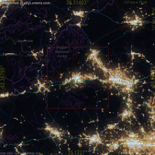
Analysis of Morganton night lights 2016
Square area 10x10 km:
 8.57%
8.57%90-99
10.31%80-89
10.84%70-79
9.44%60-69
6.29%50-59
14.86%40-49
10.84%30-39
10.66%20-29
11.71%10-19
6.47%0-9
0%Square area 50x50 km:
0.69%90-99
1%80-89
1.87%70-79
2.16%60-69
2.01%50-59
2.61%40-49
2.74%30-39
3.78%20-29
5.39%10-19
10.63%0-9
67.14%Clear (daylight) street map image can be seen on geolist.org.
Map coordinates:
36° 18' 50.5" North, 82° 23' 16.6" West
35° 44' 43.5" North, 81° 41' 5.4" West
35° 10' 21.7" North, 80° 58' 54.1" West
Some cities around Morganton sort by population:
• Hickory
31 km =19.3 mi,  92°
92°
• Lenoir
22.9 km =14.2 mi,  35°
35°
• Newton
42.7 km =26.5 mi,  101°
101°
• Saint Stephens
37.2 km =23.1 mi, 86°
• Conover
42.3 km =26.3 mi, 95°
• Marion
30.1 km =18.7 mi,  256°
256°
• Forest City
48.6 km =30.2 mi,  199°
199°
• Sawmills
20.9 km =13 mi,  65°
65°
4480219 (p: 16,692)
Sources (retrieved 2019-11-25):
» Earth at Night: Flat Maps 2012, 2016