Boiling Springs night lights from space
Night Light of Boiling Springs (South Carolina) from space (United States) Src. Average luminocity for 10x10km area is 65.6836% and for 50x50km: 33.4079%.
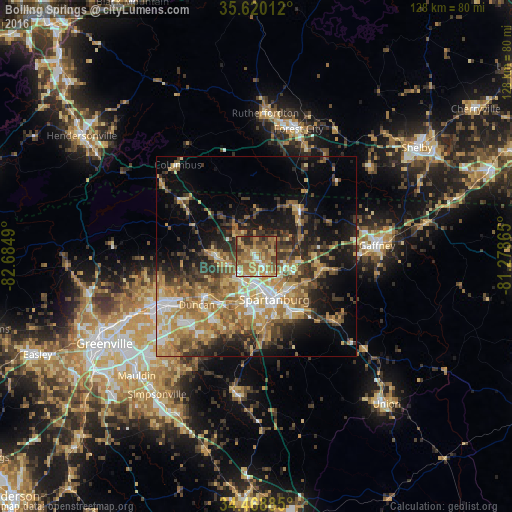
Analysis of Boiling Springs night lights 2016
Square area 10x10 km:
 6.12%
6.12%90-99
4.72%80-89
14.16%70-79
16.43%60-69
26.57%50-59
10.49%40-49
9.27%30-39
8.57%20-29
3.67%10-19
0%0-9
0%Square area 50x50 km:
3.53%90-99
3.68%80-89
5.56%70-79
6.6%60-69
7.34%50-59
5.53%40-49
4.9%30-39
6.52%20-29
6.41%10-19
12.6%0-9
37.33%Clear (daylight) street map image can be seen on geolist.org.
Map coordinates:
35° 37' 12.4" North, 82° 41' 5.6" West
35° 2' 47.4" North, 81° 58' 54.4" West
34° 28' 7.9" North, 81° 16' 43.1" West
Some cities around Boiling Springs sort by population:
• Spartanburg
11.7 km =7.3 mi,  157°
157°
• Greer
25.4 km =15.8 mi,  241°
241°
• Taylors
31.9 km =19.8 mi, 243°
• Wade Hampton
35.7 km =22.2 mi, 243°
• Five Forks
35.1 km =21.8 mi,  220°
220°
• Gaffney
30.3 km =18.8 mi,  84°
84°
• Forest City
33.7 km =20.9 mi,  18°
18°
• Valley Falls
3.5 km =2.2 mi,  169°
169°
4571805 (p: 8,219)
Sources (retrieved 2019-11-25):
» Earth at Night: Flat Maps 2012, 2016