Cherryville night lights from space
Night Light of Cherryville (North Carolina) from space (United States) Src. Average luminocity for 10x10km area is 32.207% and for 50x50km: 27.7193%.
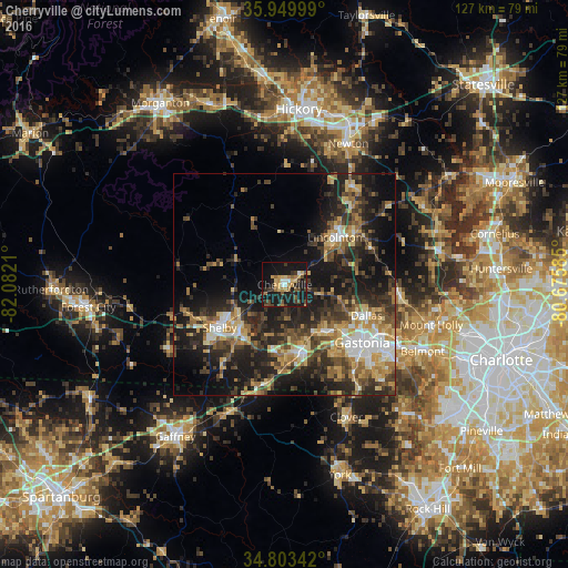
Analysis of Cherryville night lights 2016
Square area 10x10 km:
 1.83%
1.83%90-99
2.56%80-89
4.76%70-79
6.04%60-69
5.86%50-59
4.76%40-49
6.04%30-39
5.31%20-29
6.78%10-19
43.77%0-9
12.27%Square area 50x50 km:
2.63%90-99
3.26%80-89
4.35%70-79
3.9%60-69
4.43%50-59
3.86%40-49
4.98%30-39
7.21%20-29
10.08%10-19
17.63%0-9
37.67%Clear (daylight) street map image can be seen on geolist.org.
Map coordinates:
35° 56' 60" North, 82° 4' 55.6" West
35° 22' 43.5" North, 81° 22' 44.3" West
34° 48' 12.3" North, 80° 40' 33.1" West
Some cities around Cherryville sort by population:
• Gastonia
21.7 km =13.5 mi,  126°
126°
• Shelby
17.2 km =10.7 mi,  235°
235°
• Mount Holly
34.1 km =21.2 mi,  105°
105°
• Lincolnton
15.5 km =9.6 mi,  46°
46°
• Kings Mountain
15.2 km =9.4 mi,  167°
167°
• Clover
32.8 km =20.4 mi,  155°
155°
• Bessemer City
13.5 km =8.4 mi,  140°
140°
• South Gastonia
23.7 km =14.7 mi, 138°
4460465 (p: 5,974)
Sources (retrieved 2019-11-25):
» Earth at Night: Flat Maps 2012, 2016