Gaffney night lights from space
Night Light of Gaffney (South Carolina) from space (United States) Src. Average luminocity for 10x10km area is 61.0612% and for 50x50km: 20.5405%.
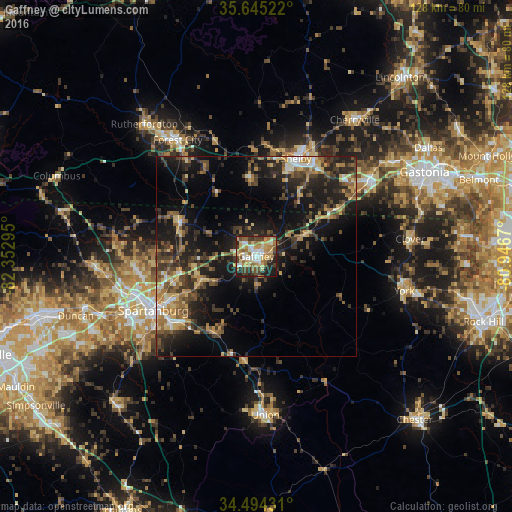
Analysis of Gaffney night lights 2016
Square area 10x10 km:
 9.09%
9.09%90-99
10.31%80-89
12.94%70-79
11.01%60-69
11.89%50-59
7.87%40-49
6.47%30-39
9.97%20-29
14.34%10-19
6.12%0-9
0%Square area 50x50 km:
1.3%90-99
1.7%80-89
3.17%70-79
2.88%60-69
3.22%50-59
3.19%40-49
4.07%30-39
5.58%20-29
7.53%10-19
16.09%0-9
51.26%Clear (daylight) street map image can be seen on geolist.org.
Map coordinates:
35° 38' 42.8" North, 82° 21' 10.6" West
35° 4' 18.4" North, 81° 38' 59.4" West
34° 29' 39.5" North, 80° 56' 48.1" West
Some cities around Gaffney sort by population:
• Spartanburg
29.1 km =18.1 mi,  242°
242°
• Shelby
26.6 km =16.5 mi,  22°
22°
• Kings Mountain
34 km =21.1 mi,  55°
55°
• Boiling Springs
30.3 km =18.8 mi,  264°
264°
• York
38.1 km =23.7 mi,  103°
103°
• Forest City
35.1 km =21.8 mi,  326°
326°
• Valley Falls
30.2 km =18.8 mi, 258°
• Clover
38.8 km =24.1 mi,  83°
83°
4579418 (p: 12,566)
Sources (retrieved 2019-11-25):
» Earth at Night: Flat Maps 2012, 2016