Centreville night lights from space
Night Light of Centreville (Illinois) from space (United States) Src. Average luminocity for 10x10km area is 86.2045% and for 50x50km: 61.6331%.
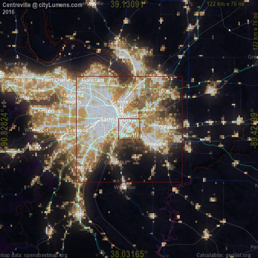
Analysis of Centreville night lights 2016
Square area 10x10 km:
 28.08%
90-99
29.71%80-89
6.01%70-79
15.42%60-69
13.15%50-59
5.68%40-49
1.95%30-39
0%20-29
0%10-19
0%0-9
0%Square area 50x50 km:
17.12%90-99
14.77%80-89
8.84%70-79
8.64%60-69
8.55%50-59
7.64%40-49
4.78%30-39
4.62%20-29
5.32%10-19
8.07%0-9
11.63%Clear (daylight) street map image can be seen on geolist.org.
Map coordinates:
39° 7' 51.3" North, 90° 49' 41.7" West
38° 35' 0.2" North, 90° 7' 30.4" West
38° 1' 53.9" North, 89° 25' 19.2" West
Some cities around Centreville sort by population:
• St. Louis
8 km =5 mi,  307°
307°
• Belleville
14.1 km =8.8 mi,  119°
119°
• Granite City
13.3 km =8.3 mi,  351°
351°
• East Saint Louis
5.1 km =3.2 mi,  333°
333°
• Fairview Heights
11.7 km =7.3 mi,  86°
86°
• Lemay
14.5 km =9 mi,  247°
247°
• Cahokia
5.8 km =3.6 mi,  256°
256°
• Swansea
13 km =8.1 mi,  114°
114°
4235600 (p: 5,027)
Sources (retrieved 2019-11-25):
» Earth at Night: Flat Maps 2012, 2016