Shiloh night lights from space
Night Light of Shiloh (Illinois) from space (United States) Src. Average luminocity for 10x10km area is 72.8847% and for 50x50km: 34.158%.
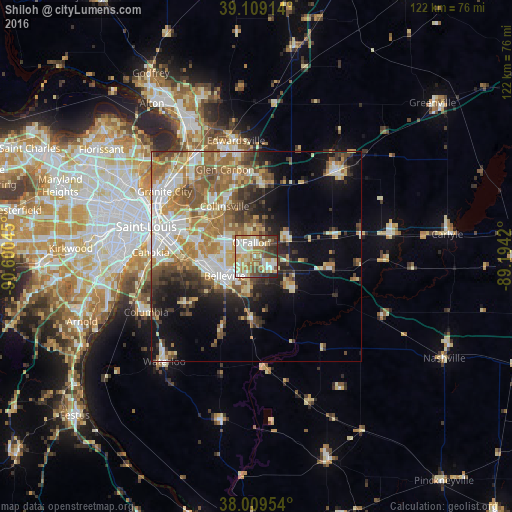
Analysis of Shiloh night lights 2016
Square area 10x10 km:
 13.64%
90-99
18.02%80-89
17.37%70-79
9.74%60-69
10.06%50-59
10.88%40-49
8.93%30-39
7.31%20-29
4.06%10-19
0%0-9
0%Square area 50x50 km:
5.56%90-99
6.78%80-89
4.84%70-79
4.88%60-69
6.25%50-59
5.9%40-49
4.06%30-39
4.49%20-29
5%10-19
9.66%0-9
42.57%Clear (daylight) street map image can be seen on geolist.org.
Map coordinates:
39° 6' 32.9" North, 90° 36' 1.6" West
38° 33' 41.2" North, 89° 53' 50.4" West
38° 0' 34.3" North, 89° 11' 39.1" West
Some cities around Shiloh sort by population:
• Belleville
8.8 km =5.5 mi,  238°
238°
• O'Fallon
3.6 km =2.2 mi,  340°
340°
• Collinsville
14.3 km =8.9 mi,  327°
327°
• Fairview Heights
8.6 km =5.3 mi,  290°
290°
• Swansea
8.5 km =5.3 mi,  249°
249°
• Troy
18.7 km =11.6 mi,  3°
3°
• Mascoutah
12 km =7.5 mi,  131°
131°
• Maryville
18.7 km =11.6 mi, 344°
4249910 (p: 12,961)
Sources (retrieved 2019-11-25):
» Earth at Night: Flat Maps 2012, 2016