Excelsior Springs night lights from space
Night Light of Excelsior Springs (Missouri) from space (United States) Src. Average luminocity for 10x10km area is 23.0544% and for 50x50km: 11.3106%.
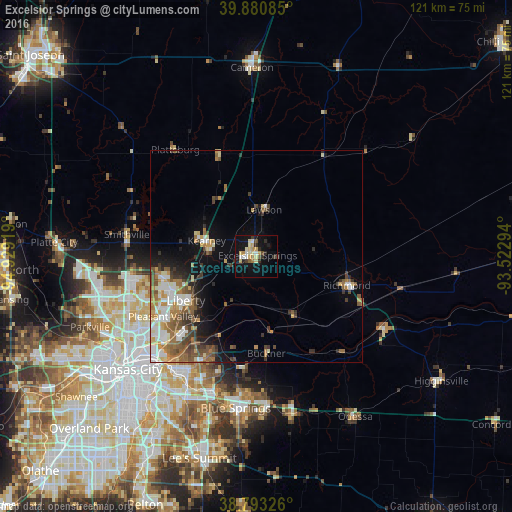
Analysis of Excelsior Springs night lights 2016
Square area 10x10 km:
 2.38%
2.38%90-99
3.57%80-89
5.1%70-79
3.23%60-69
2.04%50-59
1.53%40-49
1.53%30-39
3.74%20-29
3.4%10-19
24.32%0-9
49.15%Square area 50x50 km:
1.76%90-99
2.04%80-89
1.21%70-79
1.3%60-69
1.88%50-59
2.18%40-49
1.59%30-39
1.98%20-29
1.3%10-19
4.69%0-9
80.07%Clear (daylight) street map image can be seen on geolist.org.
Map coordinates:
39° 52' 51.1" North, 94° 55' 45.1" West
39° 20' 21" North, 94° 13' 33.8" West
38° 47' 35.7" North, 93° 31' 22.6" West
Some cities around Excelsior Springs sort by population:
• Independence
32 km =19.9 mi,  210°
210°
• East Independence
29.3 km =18.2 mi,  202°
202°
• Liberty
19.6 km =12.2 mi,  238°
238°
• Gladstone
32 km =19.9 mi, 241°
• Grain Valley
36.1 km =22.4 mi,  176°
176°
• Kearney
12.1 km =7.5 mi,  285°
285°
• Smithville
31 km =19.3 mi,  279°
279°
• Richmond
22.5 km =14 mi,  107°
107°
4385966 (p: 11,486)
Sources (retrieved 2019-11-25):
» Earth at Night: Flat Maps 2012, 2016