Grain Valley night lights from space
Night Light of Grain Valley (Missouri) from space (United States) Src. Average luminocity for 10x10km area is 36.4318% and for 50x50km: 23.3632%.
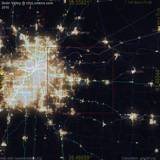
Analysis of Grain Valley night lights 2016
Square area 10x10 km:
 3.08%
3.08%90-99
4.06%80-89
4.06%70-79
5.52%60-69
4.71%50-59
9.58%40-49
7.14%30-39
7.79%20-29
9.58%10-19
33.28%0-9
11.2%Square area 50x50 km:
2.91%90-99
3.81%80-89
3.14%70-79
3.38%60-69
5.05%50-59
4.72%40-49
3.96%30-39
4.09%20-29
4.27%10-19
5.91%0-9
58.77%Clear (daylight) street map image can be seen on geolist.org.
Map coordinates:
39° 33' 33.2" North, 94° 54' 6.1" West
39° 0' 54" North, 94° 11' 54.8" West
38° 27' 59.7" North, 93° 29' 43.6" West
Some cities around Grain Valley sort by population:
• Independence
20.6 km =12.8 mi,  294°
294°
• East Independence
16.2 km =10.1 mi,  303°
303°
• Lee's Summit
19.7 km =12.2 mi,  233°
233°
• Blue Springs
7.2 km =4.5 mi,  271°
271°
• Raytown
22.9 km =14.2 mi, 268°
• Oak Grove
6.1 km =3.8 mi,  100°
100°
• Greenwood
22.1 km =13.7 mi,  214°
214°
• Odessa
21.2 km =13.2 mi,  94°
94°
4388402 (p: 13,379)
Sources (retrieved 2019-11-25):
» Earth at Night: Flat Maps 2012, 2016