Evergreen night lights from space
Night Light of Evergreen (Montana) from space (United States) Src. Average luminocity for 10x10km area is 28.6042% and for 50x50km: 2.5409%.
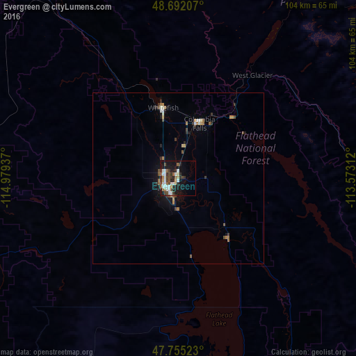
Analysis of Evergreen night lights 2016
Square area 10x10 km:
 5.8%
5.8%90-99
6.7%80-89
1.49%70-79
1.93%60-69
2.83%50-59
3.27%40-49
5.65%30-39
4.46%20-29
6.85%10-19
22.02%0-9
38.99%Square area 50x50 km:
0.29%90-99
0.42%80-89
0.13%70-79
0.29%60-69
0.35%50-59
0.36%40-49
0.47%30-39
0.37%20-29
0.51%10-19
1.81%0-9
95%Clear (daylight) street map image can be seen on geolist.org.
Map coordinates:
48° 41' 31.5" North, 114° 58' 45.7" West
48° 13' 32.8" North, 114° 16' 34.5" West
47° 45' 18.8" North, 113° 34' 23.2" West
Some cities around Evergreen sort by population:
• Missoula
152 km =94.4 mi,  171°
171°
• Kalispell
4.3 km =2.7 mi,  219°
219°
• Cranbrook, CA
178.8 km =111.1 mi,  322°
322°
• Sandpoint
168.7 km =104.8 mi,  271°
271°
• Whitefish
21.1 km =13.1 mi,  347°
347°
• Orchard Homes
152.5 km =94.8 mi, 173°
• Columbia Falls
17.7 km =11 mi,  23°
23°
• Fernie, CA
153.1 km =95.1 mi,  337°
337°
5651289 (p: 7,616)
Sources (retrieved 2019-11-25):
» Earth at Night: Flat Maps 2012, 2016