Elverta night lights from space
Night Light of Elverta (California) from space (United States) Src. Average luminocity for 10x10km area is 39.4269% and for 50x50km: 38.9498%.
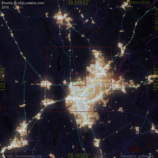
Analysis of Elverta night lights 2016
Square area 10x10 km:
 3.06%
3.06%90-99
2.04%80-89
1.19%70-79
11.22%60-69
10.03%50-59
10.2%40-49
6.12%30-39
8.67%20-29
15.65%10-19
19.56%0-9
12.24%Square area 50x50 km:
9.2%90-99
10.17%80-89
4.67%70-79
6.96%60-69
5.38%50-59
3.53%40-49
2.8%30-39
3.09%20-29
4.61%10-19
9.06%0-9
40.53%Clear (daylight) street map image can be seen on geolist.org.
Map coordinates:
39° 15' 37.2" North, 122° 9' 57.1" West
38° 42' 49.6" North, 121° 27' 45.8" West
38° 9' 47" North, 120° 45' 34.6" West
Some cities around Elverta sort by population:
• Sacramento
15 km =9.3 mi,  190°
190°
• Roseville
15.7 km =9.8 mi,  74°
74°
• Arden-Arcade
14.4 km =8.9 mi,  149°
149°
• Citrus Heights
15.8 km =9.8 mi,  92°
92°
• Antelope
11.5 km =7.1 mi, 93°
• North Highlands
8.5 km =5.3 mi,  111°
111°
• Foothill Farms
10.4 km =6.5 mi, 111°
• Rio Linda
2.8 km =1.7 mi, 154°
5346342 (p: 5,492)
Sources (retrieved 2019-11-25):
» Earth at Night: Flat Maps 2012, 2016