North Highlands night lights from space
Night Light of North Highlands (California) from space (United States) Src. Average luminocity for 10x10km area is 84.4286% and for 50x50km: 42.1831%.
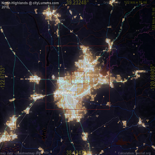

Analysis of North Highlands night lights 2016
Square area 10x10 km:
 23.64%
90-99
26.87%80-89
14.12%70-79
18.37%60-69
7.82%50-59
3.57%40-49
2.38%30-39
1.53%20-29
1.7%10-19
0%0-9
0%Square area 50x50 km:
9.7%90-99
10.81%80-89
5.02%70-79
7.52%60-69
6.14%50-59
3.99%40-49
3.24%30-39
3.76%20-29
5.7%10-19
8.61%0-9
35.51%Clear (daylight) street map image can be seen on geolist.org.
Map coordinates:
39° 13' 56.9" North, 122° 4' 31.1" West
38° 41' 8.7" North, 121° 22' 19.8" West
38° 8' 5.2" North, 120° 40' 8.6" West
Some cities around North Highlands sort by population:
• Arden-Arcade
9.3 km =5.8 mi,  183°
183°
• Citrus Heights
8.3 km =5.2 mi,  73°
73°
• Carmichael
8.5 km =5.3 mi,  153°
153°
• Antelope
4.4 km =2.7 mi,  55°
55°
• Foothill Farms
2 km =1.2 mi,  113°
113°
• Fair Oaks
9.8 km =6.1 mi,  117°
117°
• Rio Linda
6.7 km =4.2 mi,  275°
275°
• Elverta
8.5 km =5.3 mi,  291°
291°
5377640 (p: 42,694)
Sources (retrieved 2019-11-25):
» Earth at Night: Flat Maps 2012, 2016