Edinboro night lights from space
Night Light of Edinboro (Pennsylvania) from space (United States) Src. Average luminocity for 10x10km area is 9.6921% and for 50x50km: 6.367%.
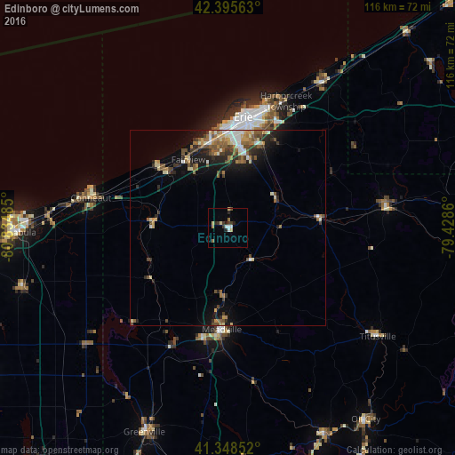
Analysis of Edinboro night lights 2016
Square area 10x10 km:
 1.11%
1.11%90-99
1.43%80-89
2.22%70-79
0%60-69
1.59%50-59
0.32%40-49
0.79%30-39
2.7%20-29
2.7%10-19
0.48%0-9
86.67%Square area 50x50 km:
0.54%90-99
0.95%80-89
0.81%70-79
0.74%60-69
1.01%50-59
1.23%40-49
1.05%30-39
1.04%20-29
1.58%10-19
3.47%0-9
87.58%Clear (daylight) street map image can be seen on geolist.org.
Map coordinates:
42° 23' 44.3" North, 80° 50' 5.5" West
41° 52' 27.2" North, 80° 7' 54.2" West
41° 20' 54.7" North, 79° 25' 43" West
Some cities around Edinboro sort by population:
• Erie
28.6 km =17.8 mi,  7°
7°
• Ashtabula
54.5 km =33.9 mi,  268°
268°
• Meadville
25.9 km =16.1 mi,  183°
183°
• Conneaut
35.9 km =22.3 mi,  283°
283°
• Northwest Harborcreek
32.6 km =20.3 mi,  20°
20°
• Corry
41 km =25.5 mi,  82°
82°
• Titusville
46.9 km =29.1 mi,  125°
125°
• Sugarcreek
54.5 km =33.9 mi,  157°
157°
5188306 (p: 6,335)
Sources (retrieved 2019-11-25):
» Earth at Night: Flat Maps 2012, 2016