East Foothills night lights from space
Night Light of East Foothills (California) from space (United States) Src. Average luminocity for 10x10km area is 56.1656% and for 50x50km: 31.846%.
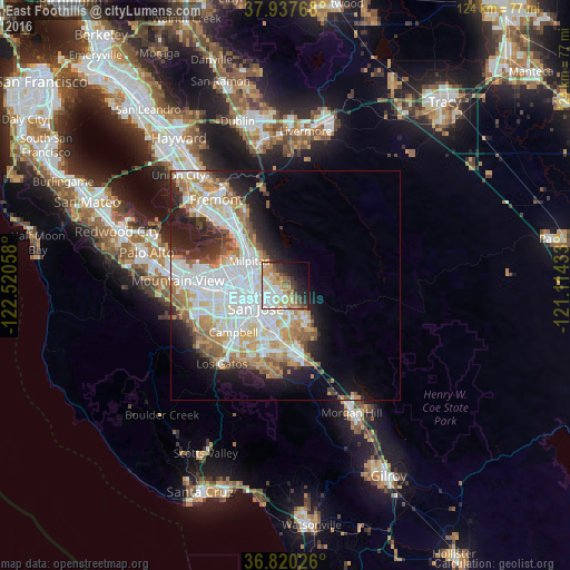
Analysis of East Foothills night lights 2016
Square area 10x10 km:
 11.53%
90-99
13.31%80-89
7.14%70-79
14.45%60-69
4.55%50-59
5.36%40-49
5.19%30-39
6.33%20-29
9.58%10-19
12.99%0-9
9.58%Square area 50x50 km:
9.05%90-99
7.86%80-89
2.76%70-79
4.66%60-69
4.26%50-59
3.31%40-49
2.35%30-39
2.46%20-29
4.99%10-19
8.2%0-9
50.12%Clear (daylight) street map image can be seen on geolist.org.
Map coordinates:
37° 56' 15.6" North, 122° 31' 14.1" West
37° 22' 51.8" North, 121° 49' 2.8" West
36° 49' 12.9" North, 121° 6' 51.6" West
Some cities around East Foothills sort by population:
• San Jose
8.3 km =5.2 mi,  235°
235°
• Sunnyvale
19.4 km =12.1 mi,  265°
265°
• Santa Clara
12.5 km =7.8 mi,  256°
256°
• Milpitas
9.5 km =5.9 mi,  303°
303°
• Cupertino
20 km =12.4 mi,  251°
251°
• Campbell
15.7 km =9.8 mi,  228°
228°
• Los Gatos
22.1 km =13.7 mi,  219°
219°
• Alum Rock
1.9 km =1.2 mi,  207°
207°
5344844 (p: 8,269)
Sources (retrieved 2019-11-25):
» Earth at Night: Flat Maps 2012, 2016