Durango night lights from space
Night Light of Durango (Colorado) from space (United States) Src. Average luminocity for 10x10km area is 28.4065% and for 50x50km: 2.0776%.
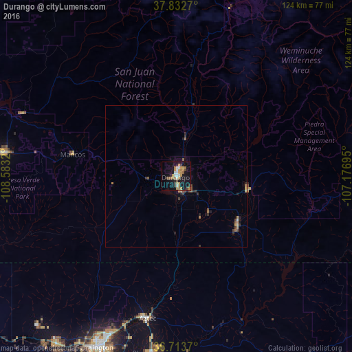
Analysis of Durango night lights 2016
Square area 10x10 km:
 2.38%
2.38%90-99
4.42%80-89
1.7%70-79
9.35%60-69
4.93%50-59
2.38%40-49
2.72%30-39
2.04%20-29
2.21%10-19
36.39%0-9
31.46%Square area 50x50 km:
0.12%90-99
0.18%80-89
0.16%70-79
0.55%60-69
0.37%50-59
0.26%40-49
0.26%30-39
0.38%20-29
0.27%10-19
1.71%0-9
95.74%Clear (daylight) street map image can be seen on geolist.org.
Map coordinates:
37° 49' 57.7" North, 108° 34' 59.5" West
37° 16' 31" North, 107° 52' 48.3" West
36° 42' 49.3" North, 107° 10' 37" West
Some cities around Durango sort by population:
• Farmington
67.9 km =42.2 mi,  206°
206°
• Montrose
133.8 km =83.1 mi,  0°
0°
• Cortez
63 km =39.1 mi,  277°
277°
• Shiprock
90 km =55.9 mi,  232°
232°
• Kirtland
73.7 km =45.8 mi,  215°
215°
• Bloomfield
63.4 km =39.4 mi,  188°
188°
• Aztec
51.4 km =31.9 mi, 191°
• Lee Acres
65.6 km =40.8 mi, 192°
5420241 (p: 18,006)
Sources (retrieved 2019-11-25):
» Earth at Night: Flat Maps 2012, 2016