Doraville night lights from space
Night Light of Doraville (Georgia) from space (United States) Src. Average luminocity for 10x10km area is 97.1066% and for 50x50km: 89.2027%.
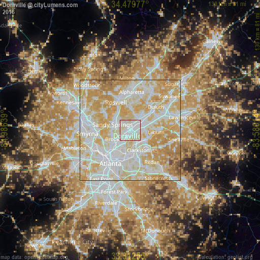
Analysis of Doraville night lights 2016
Square area 10x10 km:
 50.52%
90-99
37.76%80-89
11.71%70-79
0%60-69
0%50-59
0%40-49
0%30-39
0%20-29
0%10-19
0%0-9
0%Square area 50x50 km:
29.41%90-99
26.52%80-89
20.58%70-79
17.17%60-69
5%50-59
0.83%40-49
0.49%30-39
0%20-29
0%10-19
0%0-9
0%Clear (daylight) street map image can be seen on geolist.org.
Map coordinates:
34° 28' 47.2" North, 84° 59' 11" West
33° 53' 53.4" North, 84° 16' 59.7" West
33° 18' 45.2" North, 83° 34' 48.5" West
Some cities around Doraville sort by population:
• Sandy Springs
9.3 km =5.8 mi,  288°
288°
• Brookhaven
6.9 km =4.3 mi,  229°
229°
• Dunwoody
7.1 km =4.4 mi,  318°
318°
• North Atlanta
6.1 km =3.8 mi, 233°
• Chamblee
1.6 km =1 mi,  244°
244°
• Tucker
7.8 km =4.8 mi,  128°
128°
• North Druid Hills
9.5 km =5.9 mi,  197°
197°
• Norcross
8 km =5 mi,  53°
53°
4191768 (p: 10,896)
Sources (retrieved 2019-11-25):
» Earth at Night: Flat Maps 2012, 2016