Creve Coeur night lights from space
Night Light of Creve Coeur (Missouri) from space (United States) Src. Average luminocity for 10x10km area is 85.3571% and for 50x50km: 66.0864%.
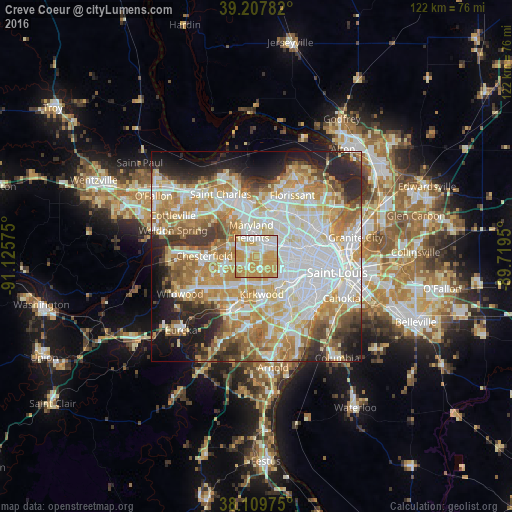
Analysis of Creve Coeur night lights 2016
Square area 10x10 km:
 19.97%
90-99
22.24%80-89
10.55%70-79
44.64%60-69
2.6%50-59
0%40-49
0%30-39
0%20-29
0%10-19
0%0-9
0%Square area 50x50 km:
18.3%90-99
15.11%80-89
9.35%70-79
11.85%60-69
9.5%50-59
5.99%40-49
4.1%30-39
5.09%20-29
8.37%10-19
7.98%0-9
4.35%Clear (daylight) street map image can be seen on geolist.org.
Map coordinates:
39° 12' 28.2" North, 91° 7' 32.7" West
38° 39' 39.2" North, 90° 25' 21.4" West
38° 6' 35.1" North, 89° 43' 10.2" West
Some cities around Creve Coeur sort by population:
• Maryland Heights
5.8 km =3.6 mi,  353°
353°
• Overland
6.9 km =4.3 mi,  49°
49°
• Saint Ann
8.1 km =5 mi,  24°
24°
• Town and Country
6.5 km =4 mi,  213°
213°
• Ladue
3.8 km =2.4 mi,  108°
108°
• Des Peres
6.7 km =4.2 mi,  187°
187°
• Brentwood
8 km =5 mi,  127°
127°
• Olivette
4.1 km =2.5 mi,  83°
83°
4382837 (p: 18,276)
Sources (retrieved 2019-11-25):
» Earth at Night: Flat Maps 2012, 2016