Darlington night lights from space
Night Light of Darlington (South Carolina) from space (United States) Src. Average luminocity for 10x10km area is 51.8938% and for 50x50km: 20.1962%.
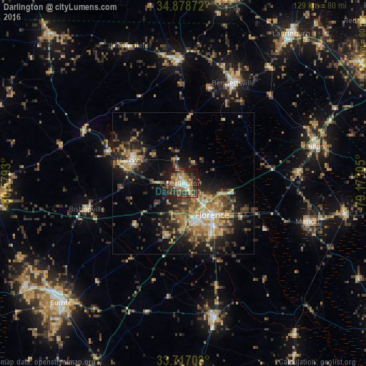
Analysis of Darlington night lights 2016
Square area 10x10 km:
 4.76%
4.76%90-99
4.4%80-89
9.71%70-79
8.42%60-69
13.74%50-59
8.97%40-49
10.44%30-39
13.37%20-29
17.58%10-19
8.42%0-9
0.18%Square area 50x50 km:
1.66%90-99
1.56%80-89
3.31%70-79
3.2%60-69
4.43%50-59
2.54%40-49
3.98%30-39
4.74%20-29
6.15%10-19
11.14%0-9
57.3%Clear (daylight) street map image can be seen on geolist.org.
Map coordinates:
34° 52' 43.4" North, 80° 34' 45.5" West
34° 17' 59.6" North, 79° 52' 34.2" West
33° 43' 1.3" North, 79° 10' 23" West
Some cities around Darlington sort by population:
• Sumter
60.1 km =37.3 mi,  225°
225°
• Florence
15.6 km =9.7 mi,  138°
138°
• Bennettsville
39.4 km =24.5 mi,  26°
26°
• Hartsville
19.9 km =12.4 mi,  294°
294°
• Lake City
49 km =30.4 mi,  166°
166°
• Marion
45.8 km =28.5 mi,  107°
107°
• Dillon
48.1 km =29.9 mi,  74°
74°
• Cheraw
44.2 km =27.5 mi,  359°
359°
4576319 (p: 6,155)
Sources (retrieved 2019-11-25):
» Earth at Night: Flat Maps 2012, 2016