Cheraw night lights from space
Night Light of Cheraw (South Carolina) from space (United States) Src. Average luminocity for 10x10km area is 28.4799% and for 50x50km: 10.5637%.
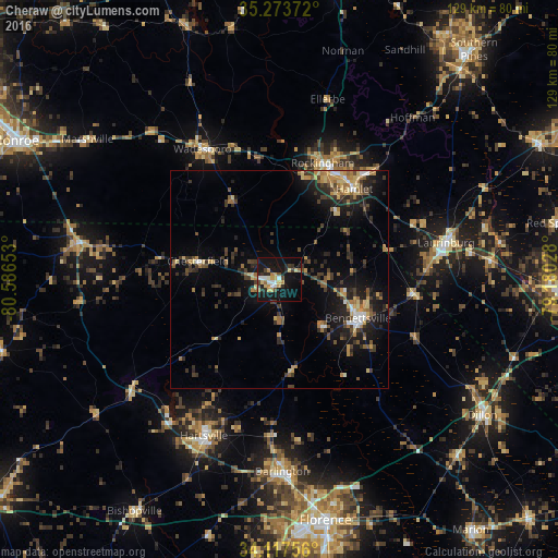
Analysis of Cheraw night lights 2016
Square area 10x10 km:
 3.48%
3.48%90-99
3.85%80-89
4.95%70-79
5.68%60-69
2.38%50-59
0.18%40-49
4.03%30-39
3.66%20-29
5.31%10-19
40.11%0-9
26.37%Square area 50x50 km:
0.74%90-99
0.62%80-89
1.67%70-79
1.39%60-69
1.72%50-59
1.08%40-49
1.9%30-39
2.77%20-29
3.27%10-19
8.09%0-9
76.75%Clear (daylight) street map image can be seen on geolist.org.
Map coordinates:
35° 16' 25.4" North, 80° 35' 11.5" West
34° 41' 51.6" North, 79° 53' 0.2" West
34° 7' 3.2" North, 79° 10' 49" West
Some cities around Cheraw sort by population:
• Laurinburg
39.4 km =24.5 mi,  77°
77°
• Rockingham
28.7 km =17.8 mi,  20°
20°
• Bennettsville
20.2 km =12.6 mi,  116°
116°
• Hartsville
40 km =24.9 mi,  205°
205°
• Dillon
56.4 km =35 mi, 123°
• Hamlet
27.1 km =16.8 mi,  39°
39°
• Darlington
44.2 km =27.5 mi,  179°
179°
• Wadesboro
34.9 km =21.7 mi,  329°
329°
4574434 (p: 5,778)
Sources (retrieved 2019-11-25):
» Earth at Night: Flat Maps 2012, 2016