Bennettsville night lights from space
Night Light of Bennettsville (South Carolina) from space (United States) Src. Average luminocity for 10x10km area is 43.3234% and for 50x50km: 10.5262%.
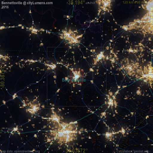
Analysis of Bennettsville night lights 2016
Square area 10x10 km:
 7.52%
7.52%90-99
6.12%80-89
8.04%70-79
4.02%60-69
6.64%50-59
4.2%40-49
5.59%30-39
6.82%20-29
15.38%10-19
33.74%0-9
1.92%Square area 50x50 km:
0.73%90-99
0.76%80-89
1.49%70-79
1.21%60-69
1.7%50-59
1.04%40-49
1.81%30-39
2.55%20-29
3.16%10-19
10.15%0-9
75.41%Clear (daylight) street map image can be seen on geolist.org.
Map coordinates:
35° 11' 38.4" North, 80° 23' 16.5" West
34° 37' 2.6" North, 79° 41' 5.2" West
34° 2' 12.2" North, 78° 58' 54" West
Some cities around Bennettsville sort by population:
• Florence
47.5 km =29.5 mi,  188°
188°
• Laurinburg
26.7 km =16.6 mi,  49°
49°
• Rockingham
36.7 km =22.8 mi,  347°
347°
• Hartsville
44.7 km =27.8 mi,  232°
232°
• Dillon
36.4 km =22.6 mi,  127°
127°
• Hamlet
29.8 km =18.5 mi,  358°
358°
• Darlington
39.4 km =24.5 mi,  206°
206°
• Cheraw
20.2 km =12.6 mi,  296°
296°
4570634 (p: 8,605)
Sources (retrieved 2019-11-25):
» Earth at Night: Flat Maps 2012, 2016