Dana Point night lights from space
Night Light of Dana Point (California) from space (United States) Src. Average luminocity for 10x10km area is 40.7413% and for 50x50km: 22.5213%.

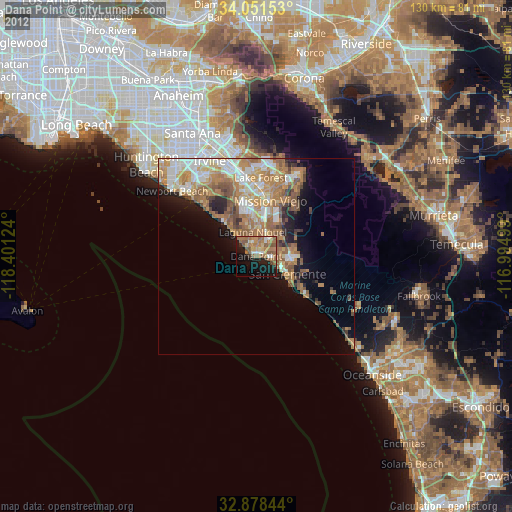
Analysis of Dana Point night lights 2016
Square area 10x10 km:
 4.9%
4.9%90-99
3.5%80-89
4.2%70-79
5.77%60-69
9.44%50-59
14.86%40-49
6.64%30-39
3.32%20-29
9.62%10-19
22.55%0-9
15.21%Square area 50x50 km:
4.25%90-99
4.12%80-89
2.4%70-79
3.18%60-69
5.41%50-59
4.31%40-49
3.06%30-39
1.82%20-29
2.88%10-19
5.81%0-9
62.76%Clear (daylight) street map image can be seen on geolist.org.
Map coordinates:
34° 3' 5.5" North, 118° 24' 4.5" West
33° 28' 1.1" North, 117° 41' 53.2" West
32° 52' 42.4" North, 116° 59' 42" West
Some cities around Dana Point sort by population:
• Mission Viejo
15 km =9.3 mi,  9°
9°
• Laguna Niguel
6.2 km =3.9 mi,  351°
351°
• San Clemente
9.1 km =5.7 mi,  119°
119°
• Aliso Viejo
11.2 km =7 mi, 346°
• San Juan Capistrano
5.1 km =3.2 mi,  40°
40°
• Laguna Beach
11.5 km =7.1 mi,  316°
316°
• Ladera Ranch
12.9 km =8 mi,  26°
26°
• Las Flores
15 km =9.3 mi, 26°
5341483 (p: 34,181)
Sources (retrieved 2019-11-25):
» Earth at Night: Flat Maps 2012, 2016