Damascus night lights from space
Night Light of Damascus (Maryland) from space (United States) Src. Average luminocity for 10x10km area is 29.9252% and for 50x50km: 32.4981%.
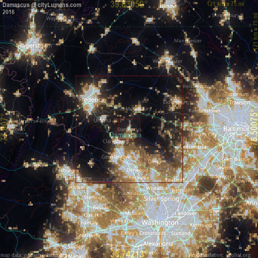
Analysis of Damascus night lights 2016
Square area 10x10 km:
 1.02%
1.02%90-99
0.51%80-89
3.91%70-79
1.36%60-69
5.1%50-59
9.86%40-49
9.52%30-39
7.48%20-29
9.52%10-19
42.86%0-9
8.84%Square area 50x50 km:
4.73%90-99
4.89%80-89
3.44%70-79
4.4%60-69
5.64%50-59
6.18%40-49
4.74%30-39
5.71%20-29
9.11%10-19
18.56%0-9
32.62%Clear (daylight) street map image can be seen on geolist.org.
Map coordinates:
39° 49' 49.9" North, 77° 54' 25.2" West
39° 17' 18.4" North, 77° 12' 13.9" West
38° 44' 31.7" North, 76° 30' 2.7" West
Some cities around Damascus sort by population:
• Germantown
14.1 km =8.8 mi,  204°
204°
• Gaithersburg
16.1 km =10 mi,  179°
179°
• Montgomery Village
12.4 km =7.7 mi, 176°
• Redland
16.7 km =10.4 mi,  162°
162°
• Clarksburg
8.5 km =5.3 mi,  229°
229°
• Green Valley
8.4 km =5.2 mi,  286°
286°
• Mount Airy
10.6 km =6.6 mi,  23°
23°
• Urbana
13.4 km =8.3 mi, 288°
4352728 (p: 15,257)
Sources (retrieved 2019-11-25):
» Earth at Night: Flat Maps 2012, 2016