Green Valley night lights from space
Night Light of Green Valley (Maryland) from space (United States) Src. Average luminocity for 10x10km area is 24.0306% and for 50x50km: 26.9531%.
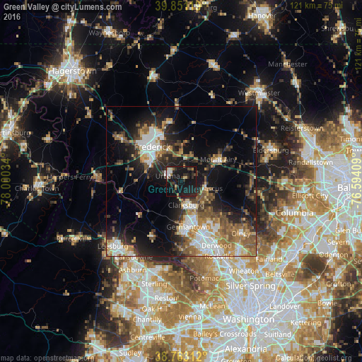
Analysis of Green Valley night lights 2016
Square area 10x10 km:
 2.04%
2.04%90-99
3.06%80-89
3.06%70-79
1.02%60-69
1.87%50-59
0.85%40-49
4.08%30-39
5.44%20-29
9.01%10-19
56.8%0-9
12.76%Square area 50x50 km:
4.46%90-99
4.19%80-89
2.81%70-79
3.3%60-69
4.38%50-59
4.61%40-49
3.61%30-39
4.45%20-29
6.9%10-19
15.71%0-9
45.57%Clear (daylight) street map image can be seen on geolist.org.
Map coordinates:
39° 51' 4.3" North, 78° 0' 1.2" West
39° 18' 33.4" North, 77° 17' 50" West
38° 45' 47.2" North, 76° 35' 38.7" West
Some cities around Green Valley sort by population:
• Germantown
15.3 km =9.5 mi,  171°
171°
• Frederick
15.2 km =9.4 mi,  320°
320°
• Ballenger Creek
13.8 km =8.6 mi,  300°
300°
• Damascus
8.4 km =5.2 mi,  106°
106°
• Clarksburg
8 km =5 mi, 168°
• Mount Airy
14.3 km =8.9 mi,  58°
58°
• Urbana
5 km =3.1 mi,  291°
291°
• Spring Ridge
11.3 km =7 mi,  335°
335°
4356836 (p: 12,262)
Sources (retrieved 2019-11-25):
» Earth at Night: Flat Maps 2012, 2016